Geolocate

Bosio topographic map

Click on the map to display elevation.

About this map

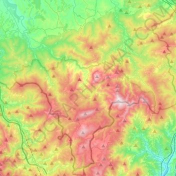
Name: Bosio topographic map, elevation, terrain.

Location: Bosio, Alessandria, Piedmont, Italy (44.48802 8.73142 44.66514 8.82904)

Average elevation: 531 m

Minimum elevation: 71 m

Maximum elevation: 1,163 m

Other topographic maps

Click on a map to view its topography, its elevation and its terrain.

Po

Italy > Piedmont > Alessandria > Coniolo

Average elevation: 146 m

Rosingo

Italy > Piedmont > Alessandria > Cerrina Monferrato

Average elevation: 234 m

Valle Scura

Italy > Piedmont > Alessandria > Brignano-Frascata

Average elevation: 396 m

Molini

Italy > Piedmont > Alessandria > Fraconalto

Average elevation: 624 m

Zanco

Italy > Piedmont > Alessandria > Villadeati

Average elevation: 241 m

Ciglione

Italy > Piedmont > Alessandria > Ponzone

Average elevation: 387 m

Gnocchetto

Italy > Piedmont > Alessandria > Ovada

Average elevation: 427 m

Mandrogne

Italy > Piedmont > Alessandria > Alessandria

Average elevation: 120 m

Incisa

Italy > Piedmont > Alessandria > Montacuto

Average elevation: 533 m

Gear up for your next adventure:

🧭Orienteering Kit - Tools for map reading and navigation in the wild
🧭GPS Handheld Device - Reliable GPS navigation for outdoor adventures
💡Compact LED Flashlight - Powerful and portable flashlight for outdoor use
🧦Merino Wool Socks - Moisture-wicking comfort for long-distance hiking
🧥Ultralight Puffy Jacket - Maximum warmth that packs down to the size of an orange

As an Amazon Associate, this site earns from qualifying purchases at no extra cost to you.