Geolocate

Rain topographic map

Click on the map to display elevation.

About this map

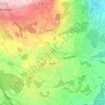
Name: Rain topographic map, elevation, terrain.

Location: Rain, Lucerne, 6026, Switzerland (47.11768 8.23029 47.14965 8.29358)

Average elevation: 578 m

Minimum elevation: 473 m

Maximum elevation: 714 m

Other topographic maps

Click on a map to view its topography, its elevation and its terrain.

Alpach

Switzerland > Lucerne > Escholzmatt-Marbach > Escholzmatt

Average elevation: 966 m

Hellbühl

Switzerland > Lucerne

Average elevation: 639 m

Sörenberg

Switzerland > Lucerne

Average elevation: 1,386 m

Marbachegg

Switzerland > Lucerne > Escholzmatt-Marbach

Average elevation: 1,159 m

Gunzwil

Switzerland > Lucerne

Average elevation: 671 m

Schiltalp

Switzerland > Lucerne > Kriens

Average elevation: 962 m

Schloss Meggenhorn

Switzerland > Lucerne > Meggen

Average elevation: 450 m

Allmendhubel

Switzerland > Lucerne > Menznau

Average elevation: 636 m

Schachen

Switzerland > Lucerne > Werthenstein > Schachen

Average elevation: 671 m

Gear up for your next adventure:

🛌Insulated Sleeping Pad - Critical thermal barrier between you and the cold ground
🥾Hiking Shoes - Durable and comfortable shoes for trail hiking
🧥Thermal Layer - Insulating layer for cold outdoor conditions
🧴Waterproofing Spray - Restore the DWR coating on jackets and tents
🕶️Polarized Sunglasses - Reduces glare from snow and water at high elevations

As an Amazon Associate, this site earns from qualifying purchases at no extra cost to you.