
Sainte-Sévère-sur-Indre topographic map
Interactive map
Click on the map to display elevation.
About this map
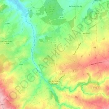
Name: Sainte-Sévère-sur-Indre topographic map, elevation, terrain.
Average elevation: 287 m
Minimum elevation: 218 m
Maximum elevation: 377 m
La topographie, accidentée au sud du village, est au contraire assez plane au nord, en allant vers la Châtre. Dans un paysage de haies et de bouchures typique du Boischaut Sud, le village ouvre la porte au Massif central avec la présence du plateau du bas Berry au sud de la commune avec des points à plus de 400 m d'altitude en se rapprochant du département de la Creuse.
Other topographic maps
Click on a map to view its topography, its elevation and its terrain.
Pérassay
France > Centre-Val de Loire > Indre
Pérassay, La Châtre, Indre, Centre-Val de Loire, France métropolitaine, 36160, France
Average elevation: 362 m
Boulaie
France > Centre-Val de Loire > Indre > Saint-Genou
Boulaie, Saint-Genou, Châteauroux, Indre, Centre-Val de Loire, France métropolitaine, 36500, France
Average elevation: 125 m
Châteauroux
France > Centre-Val de Loire > Indre > Châteauroux
Châteauroux, Indre, Centre-Val de Loire, France métropolitaine, 36000, France
Average elevation: 153 m
Saint-Plantaire
France > Centre-Val de Loire > Indre
Saint-Plantaire, La Châtre, Indre, Centre-Val de Loire, France métropolitaine, 36190, France
Average elevation: 295 m
Saint-Martin-de-Lamps
France > Centre-Val de Loire > Indre > Levroux
Saint-Martin-de-Lamps, Levroux, Châteauroux, Indre, Centre-Val de Loire, France métropolitaine, 36110, France
Average elevation: 150 m
Pouligny-Notre-Dame
France > Centre-Val de Loire > Indre
Pouligny-Notre-Dame, La Châtre, Indre, Centre-Val de Loire, France métropolitaine, 36160, France
Average elevation: 350 m
Nohant-Vic
France > Centre-Val de Loire > Indre
Nohant-Vic, La Châtre, Indre, Centre-Val de Loire, France métropolitaine, 36400, France
Average elevation: 217 m
Vicq-sur-Nahon
France > Centre-Val de Loire > Indre
Vicq-sur-Nahon, Châteauroux, Indre, Centre-Val de Loire, France métropolitaine, 36600, France
Average elevation: 148 m
Concremiers
France > Centre-Val de Loire > Indre
Concremiers, Le Blanc, Indre, Centre-Val de Loire, France métropolitaine, 36300, France
Average elevation: 112 m
Mézières-en-Brenne
France > Centre-Val de Loire > Indre
Mézières-en-Brenne, Le Blanc, Indre, Centre-Val de Loire, France métropolitaine, 36290, France
Average elevation: 100 m
Le Pêchereau
France > Centre-Val de Loire > Indre
Le Pêchereau, Châteauroux, Indre, Centre-Val de Loire, France métropolitaine, 36200, France
Average elevation: 165 m
Bouesse
France > Centre-Val de Loire > Indre
Bouesse, Châteauroux, Indre, Centre-Val de Loire, France métropolitaine, 36200, France
Average elevation: 187 m
Série
France > Centre-Val de Loire > Indre > Cluis
Série, Cluis, La Châtre, Indre, Centre-Val de Loire, France métropolitaine, 36340, France
Average elevation: 264 m
Le Moulin Neuf
France > Centre-Val de Loire > Indre > Le Menoux
Le Moulin Neuf, Le Menoux, Châteauroux, Indre, Centre-Val de Loire, France métropolitaine, 36200, France
Average elevation: 164 m
Roussines
France > Centre-Val de Loire > Indre
Roussines, Le Blanc, Indre, Centre-Val de Loire, France métropolitaine, 36170, France
Average elevation: 211 m
Varennes-sur-Fouzon
France > Centre-Val de Loire > Indre > Val-Fouzon
Varennes-sur-Fouzon, Val-Fouzon, Issoudun, Indre, Centre-Val de Loire, France métropolitaine, 36210, France
Average elevation: 100 m
Briantes
France > Centre-Val de Loire > Indre
Briantes, La Châtre, Indre, Centre-Val de Loire, France métropolitaine, 36400, France
Average elevation: 251 m
Gehée
France > Centre-Val de Loire > Indre
Gehée, Châteauroux, Indre, Centre-Val de Loire, France métropolitaine, 36240, France
Average elevation: 142 m
Montgivray
France > Centre-Val de Loire > Indre
Montgivray, La Châtre, Indre, Centre-Val de Loire, France métropolitaine, 36400, France
Average elevation: 223 m
Gargilesse-Dampierre
France > Centre-Val de Loire > Indre
Gargilesse-Dampierre, Châteauroux, Indre, Centre-Val de Loire, France métropolitaine, 36190, France
Average elevation: 216 m
Luzeret
France > Centre-Val de Loire > Indre
Luzeret, Le Blanc, Indre, Centre-Val de Loire, France métropolitaine, 36800, France
Average elevation: 170 m
La Jarrige
France > Centre-Val de Loire > Indre > Douadic
La Jarrige, Douadic, Le Blanc, Indre, Centre-Val de Loire, France métropolitaine, 36300, France
Average elevation: 103 m
Mérigny
France > Centre-Val de Loire > Indre
Mérigny, Le Blanc, Indre, Centre-Val de Loire, France métropolitaine, 36220, France
Average elevation: 111 m
Le Poinçonnet
France > Centre-Val de Loire > Indre
Le Poinçonnet, Châteauroux, Indre, Centre-Val de Loire, France métropolitaine, 36330, France
Average elevation: 164 m
Velles
France > Centre-Val de Loire > Indre
Velles, Châteauroux, Indre, Centre-Val de Loire, France métropolitaine, 36330, France
Average elevation: 152 m
La Grande Métairie
France > Centre-Val de Loire > Indre > Bouesse
La Grande Métairie, Bouesse, Châteauroux, Indre, Centre-Val de Loire, France métropolitaine, 36200, France
Average elevation: 190 m
Clion
France > Centre-Val de Loire > Indre
Clion, Châteauroux, Indre, Centre-Val de Loire, France métropolitaine, 36700, France
Average elevation: 119 m
Ciron
France > Centre-Val de Loire > Indre
Ciron, Le Blanc, Indre, Centre-Val de Loire, France métropolitaine, 36300, France
Average elevation: 121 m
Néons-sur-Creuse
France > Centre-Val de Loire > Indre
Néons-sur-Creuse, Le Blanc, Indre, Centre-Val de Loire, France métropolitaine, 36220, France
Average elevation: 96 m
Chambrisse
France > Centre-Val de Loire > Indre > Châtillon-sur-Indre
Chambrisse, Châtillon-sur-Indre, Châteauroux, Indre, Centre-Val de Loire, France métropolitaine, 36700, France
Average elevation: 121 m
Brenne
France > Centre-Val de Loire > Indre > Ardentes
Brenne, Ardentes, Châteauroux, Indre, Centre-Val de Loire, France métropolitaine, 36120, France
Average elevation: 173 m
Bélâbre
France > Centre-Val de Loire > Indre
Bélâbre, Le Blanc, Indre, Centre-Val de Loire, France métropolitaine, 36370, France
Average elevation: 126 m
Le Brolet
France > Centre-Val de Loire > Indre > Sazeray
Le Brolet, Sazeray, La Châtre, Indre, Centre-Val de Loire, France métropolitaine, 36160, France
Average elevation: 402 m
Meunet-Planches
France > Centre-Val de Loire > Indre
Meunet-Planches, Issoudun, Indre, Centre-Val de Loire, France métropolitaine, 36100, France
Average elevation: 157 m
Saint-Denis-de-Jouhet
France > Centre-Val de Loire > Indre
Saint-Denis-de-Jouhet, La Châtre, Indre, Centre-Val de Loire, France métropolitaine, 36230, France
Average elevation: 294 m
Lourouer-Saint-Laurent
France > Centre-Val de Loire > Indre
Lourouer-Saint-Laurent, La Châtre, Indre, Centre-Val de Loire, France métropolitaine, 36400, France
Average elevation: 213 m
Sazeray
France > Centre-Val de Loire > Indre
Sazeray, La Châtre, Indre, Centre-Val de Loire, France métropolitaine, 36160, France
Average elevation: 351 m
Arthon
France > Centre-Val de Loire > Indre
Arthon, Châteauroux, Indre, Centre-Val de Loire, France métropolitaine, 36330, France
Average elevation: 156 m
Luant
France > Centre-Val de Loire > Indre
Luant, Châteauroux, Indre, Centre-Val de Loire, France métropolitaine, 36350, France
Average elevation: 146 m
Brives
France > Centre-Val de Loire > Indre
Brives, Issoudun, Indre, Centre-Val de Loire, France métropolitaine, 36100, France
Average elevation: 155 m
Mosnay
France > Centre-Val de Loire > Indre
Mosnay, Châteauroux, Indre, Centre-Val de Loire, France métropolitaine, 36200, France
Average elevation: 174 m
Les Grands Champs Forts
France > Centre-Val de Loire > Indre > Saint-Aoustrille
Les Grands Champs Forts, Saint-Aoustrille, Issoudun, Indre, Centre-Val de Loire, France métropolitaine, 36100, France
Average elevation: 139 m
Mers-sur-Indre
France > Centre-Val de Loire > Indre
Mers-sur-Indre, La Châtre, Indre, Centre-Val de Loire, France métropolitaine, 36230, France
Average elevation: 206 m
Montlevicq
France > Centre-Val de Loire > Indre
Montlevicq, La Châtre, Indre, Centre-Val de Loire, France métropolitaine, 36400, France
Average elevation: 230 m
Neuvy-Saint-Sépulchre
France > Centre-Val de Loire > Indre
Neuvy-Saint-Sépulchre, La Châtre, Indre, Centre-Val de Loire, France métropolitaine, 36230, France
Average elevation: 218 m
Azay-le-Ferron
France > Centre-Val de Loire > Indre
Azay-le-Ferron, Le Blanc, Indre, Centre-Val de Loire, France métropolitaine, 36290, France
Average elevation: 114 m
Ceaulmont
France > Centre-Val de Loire > Indre
Ceaulmont, Châteauroux, Indre, Centre-Val de Loire, France métropolitaine, 36200, France
Average elevation: 200 m
Néret
France > Centre-Val de Loire > Indre
Néret, La Châtre, Indre, Centre-Val de Loire, France métropolitaine, 36400, France
Average elevation: 243 m
Bousset
France > Centre-Val de Loire > Indre > Éguzon-Chantôme > Éguzon
Bousset, Éguzon, Éguzon-Chantôme, Châteauroux, Indre, Centre-Val de Loire, France métropolitaine, 36270, France
Average elevation: 246 m
La Pérouille
France > Centre-Val de Loire > Indre
La Pérouille, Le Blanc, Indre, Centre-Val de Loire, France métropolitaine, 36350, France
Average elevation: 148 m