
Make a donation
Gear up for your next adventure:
As an Amazon Associate, this site earns from qualifying purchases at no extra cost to you.
Boulaie topographic map
Click on the map to display elevation.
Make a donation
Gear up for your next adventure:
As an Amazon Associate, this site earns from qualifying purchases at no extra cost to you.
About this map
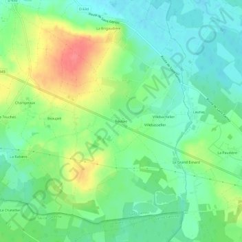
Name: Boulaie topographic map, elevation, terrain.
Average elevation: 125 m
Minimum elevation: 101 m
Maximum elevation: 166 m
Make a donation
Gear up for your next adventure:
As an Amazon Associate, this site earns from qualifying purchases at no extra cost to you.
Other topographic maps
Click on a map to view its topography, its elevation and its terrain.
L'Indre
France > Centre-Val de Loire > Indre > Saint-Genou
Il prend sa source dans le département du Cher, à 454 m d'altitude, au lieu-dit « Beddes », sur le territoire de la commune de Saint-Priest-la-Marche, puis s'écoule vers le nord-ouest.
Average elevation: 108 m