Geolocate

Tamins topographic map

Click on the map to display elevation.

About this map

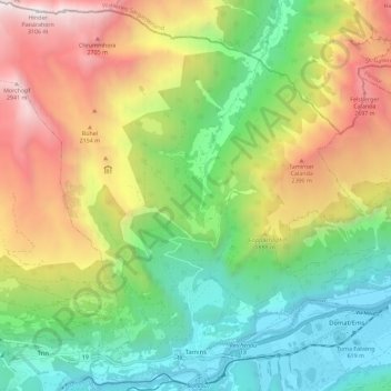
Name: Tamins topographic map, elevation, terrain.

Location: Tamins, Imboden, Grisons, 7015, Switzerland (46.82143 9.34158 46.89967 9.45563)

Average elevation: 1,549 m

Minimum elevation: 568 m

Maximum elevation: 3,092 m

Other topographic maps

Click on a map to view its topography, its elevation and its terrain.

Reichenau

Switzerland > Grisons > Imboden > Tamins

Average elevation: 759 m

Ringelspitz

Switzerland > Grisons > Imboden > Trin

Average elevation: 2,628 m

Gear up for your next adventure:

🧤Insulated Winter Gloves - Heavy-duty protection for sub-zero Canadian adventures
🥾Trail Hiking Socks - Comfortable socks to prevent blisters and fatigue
🥾Durable Hiking Shoes - Long-lasting shoes for frequent hiking
🥾Mountain Hiking Boots - High-traction boots for rocky terrain
🕯️Camping Lantern - Illuminates your entire campsite with high-efficiency LEDs

As an Amazon Associate, this site earns from qualifying purchases at no extra cost to you.