Geolocate

Reichenau topographic map

Click on the map to display elevation.

About this map

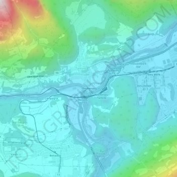
Name: Reichenau topographic map, elevation, terrain.

Location: Reichenau, Tamins, Imboden, Grisons, 7015, Switzerland (46.80475 9.38906 46.84475 9.42906)

Average elevation: 759 m

Minimum elevation: 573 m

Maximum elevation: 1,742 m

Gear up for your next adventure:

🥾Hiking Shorts - Breathable shorts suitable for summer hikes
🔭Compact Monocular - One-handed bird watching and trail spotting
💧Hydration Pack - Hands-free hydration system for long hikes
🧥Packable Rain Jacket - Breathable waterproof layer for unpredictable weather
🦯Trekking Poles - Reduced impact on joints for steep topographic climbs

As an Amazon Associate, this site earns from qualifying purchases at no extra cost to you.