Geolocate

Springtown topographic map

Click on the map to display elevation.

About this map

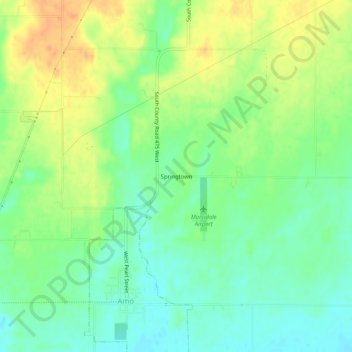
Name: Springtown topographic map, elevation, terrain.

Location: Springtown, Hendricks County, Indiana, 46103, United States (39.68227 -86.62611 39.72227 -86.58611)

Average elevation: 262 m

Minimum elevation: 245 m

Maximum elevation: 283 m

Other topographic maps

Click on a map to view its topography, its elevation and its terrain.

North Salem

United States > Indiana > Hendricks County

Average elevation: 278 m

Stilesville

United States > Indiana > Hendricks County

Average elevation: 240 m

Coatesville

United States > Indiana > Hendricks County

Average elevation: 271 m

Pittsboro

United States > Indiana > Hendricks County

Average elevation: 285 m

Amo

United States > Indiana > Hendricks County

Average elevation: 255 m

Avon

United States > Indiana > Hendricks County

Average elevation: 254 m

Danville

United States > Indiana > Hendricks County

Average elevation: 281 m

Clayton

United States > Indiana > Hendricks County

Average elevation: 263 m

Lizton

United States > Indiana > Hendricks County

Average elevation: 292 m

Gear up for your next adventure:

🕶️Polarized Sunglasses - Protect your eyes with durable polarized lenses
🧶550 Survival Paracord - Versatile utility cord for emergency repairs and rigging
🪜Heavy Duty Carabiners - Multi-use clips for securing gear to your backpack
🪑Ultralight Camping Stool - Compact seating for rest stops during long hikes
🥾Mountain Trail Shoes - High-traction shoes for mountain trails

As an Amazon Associate, this site earns from qualifying purchases at no extra cost to you.