
Make a donation
Gear up for your next adventure:
As an Amazon Associate, this site earns from qualifying purchases at no extra cost to you.
Arroio do Sal topographic map
Click on the map to display elevation.
Make a donation
Gear up for your next adventure:
As an Amazon Associate, this site earns from qualifying purchases at no extra cost to you.
Arroio do Sal
Localiza-se a uma latitude de 29º33'05" sul e a uma longitude de 49º53'20" oeste, estando a uma altitude de 6 metros. Sua população fixa foi estimada em 2016 em 8.921 habitantes. A população temporária na alta estação de veraneio alcança cerca de 100.000 habitantes. Possui uma área de 111,0 km².
Make a donation
Gear up for your next adventure:
As an Amazon Associate, this site earns from qualifying purchases at no extra cost to you.
About this map
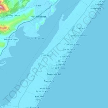
Name: Arroio do Sal topographic map, elevation, terrain.
Average elevation: 19 m
Minimum elevation: -2 m
Maximum elevation: 909 m
Make a donation
Gear up for your next adventure:
As an Amazon Associate, this site earns from qualifying purchases at no extra cost to you.
Other topographic maps
Click on a map to view its topography, its elevation and its terrain.
Capão Novo
Brasil > Rio Grande do Sul > Aglomeração Urbana do Litoral Norte > Capão da Canoa
Average elevation: 4 m
Morro do Farol
Brasil > Rio Grande do Sul > Aglomeração Urbana do Litoral Norte > Torres
Average elevation: 4 m
Mirante do Morro da Borússia
Brasil > Rio Grande do Sul > Aglomeração Urbana do Litoral Norte > Osório
Average elevation: 197 m
Praça das Carretas
Brasil > Rio Grande do Sul > Aglomeração Urbana do Litoral Norte > Osório
Average elevation: 22 m
Make a donation
Gear up for your next adventure:
As an Amazon Associate, this site earns from qualifying purchases at no extra cost to you.
Balneário Atlântico
Brasil > Rio Grande do Sul > Aglomeração Urbana do Litoral Norte > Arroio do Sal
Average elevation: 5 m
Fernando Ferrari
Brasil > Rio Grande do Sul > Aglomeração Urbana do Litoral Norte > Três Cachoeiras
Average elevation: 68 m
Faxinal do Morro Alto
Brasil > Rio Grande do Sul > Aglomeração Urbana do Litoral Norte > Maquiné
Average elevation: 5 m
Praia Nova Tramandai Sul
Brasil > Rio Grande do Sul > Aglomeração Urbana do Litoral Norte > Tramandaí
Average elevation: 4 m
Make a donation
Gear up for your next adventure:
As an Amazon Associate, this site earns from qualifying purchases at no extra cost to you.
Morro das Furnas
Brasil > Rio Grande do Sul > Aglomeração Urbana do Litoral Norte > Torres
Average elevation: 4 m
Praia Real
Brasil > Rio Grande do Sul > Aglomeração Urbana do Litoral Norte > Torres
Average elevation: 5 m
Praia Paraíso
Brasil > Rio Grande do Sul > Aglomeração Urbana do Litoral Norte > Torres
Average elevation: 5 m
Morro da Borússia
Brasil > Rio Grande do Sul > Aglomeração Urbana do Litoral Norte > Osório
Average elevation: 199 m
Make a donation
Gear up for your next adventure:
As an Amazon Associate, this site earns from qualifying purchases at no extra cost to you.
Guarita
Brasil > Rio Grande do Sul > Aglomeração Urbana do Litoral Norte > Torres
Average elevation: 4 m
Dunas Altas
Brasil > Rio Grande do Sul > Aglomeração Urbana do Litoral Norte > Palmares do Sul
Average elevation: 4 m
Praia Santa Helena
Brasil > Rio Grande do Sul > Aglomeração Urbana do Litoral Norte > Torres
Average elevation: 5 m
Magistério
Brasil > Rio Grande do Sul > Aglomeração Urbana do Litoral Norte > Balneário Pinhal
Average elevation: 4 m
Make a donation
Gear up for your next adventure:
As an Amazon Associate, this site earns from qualifying purchases at no extra cost to you.
Mariápolis
Brasil > Rio Grande do Sul > Aglomeração Urbana do Litoral Norte > Osório
Average elevation: 3 m
Amaragi
Brasil > Rio Grande do Sul > Aglomeração Urbana do Litoral Norte > Terra de Areia
Average elevation: 5 m
Alto Caraá
Brasil > Rio Grande do Sul > Aglomeração Urbana do Litoral Norte > Caraá
Average elevation: 211 m
Lagoa da Ilhota
Brasil > Rio Grande do Sul > Aglomeração Urbana do Litoral Norte > Osório
Average elevation: 14 m
Make a donation
Gear up for your next adventure:
As an Amazon Associate, this site earns from qualifying purchases at no extra cost to you.
Bananeiras
Brasil > Rio Grande do Sul > Aglomeração Urbana do Litoral Norte > Itati
Average elevation: 326 m
Praça Pedro Cardoso Duarte
Brasil > Rio Grande do Sul > Aglomeração Urbana do Litoral Norte > Torres
Average elevation: 5 m
Praia Lagoa do Jardim
Brasil > Rio Grande do Sul > Aglomeração Urbana do Litoral Norte > Torres
Average elevation: 6 m
Morro Azul
Brasil > Rio Grande do Sul > Aglomeração Urbana do Litoral Norte > Três Cachoeiras
Average elevation: 87 m
Make a donation
Gear up for your next adventure:
As an Amazon Associate, this site earns from qualifying purchases at no extra cost to you.
Pixirica
Brasil > Rio Grande do Sul > Aglomeração Urbana do Litoral Norte > Morrinhos do Sul > Pixirica
Average elevation: 69 m
Alto Rio dos Sinos
Brasil > Rio Grande do Sul > Aglomeração Urbana do Litoral Norte > Caraá
Average elevation: 184 m