
Make a donation
Gear up for your next adventure:
As an Amazon Associate, this site earns from qualifying purchases at no extra cost to you.
Capão Novo topographic map
Click on the map to display elevation.
Make a donation
Gear up for your next adventure:
As an Amazon Associate, this site earns from qualifying purchases at no extra cost to you.
About this map
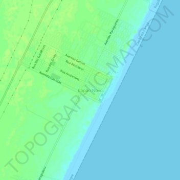
Name: Capão Novo topographic map, elevation, terrain.
Average elevation: 4 m
Minimum elevation: 0 m
Maximum elevation: 10 m
Make a donation
Gear up for your next adventure:
As an Amazon Associate, this site earns from qualifying purchases at no extra cost to you.
Other topographic maps
Click on a map to view its topography, its elevation and its terrain.
Capão Novo
Brasil > Rio Grande do Sul > Aglomeração Urbana do Litoral Norte > Capão da Canoa
Localiza-se na latitude 29º44'44" sul e na longitude 50º00'35" oeste, elevando-se à altitude de 4,80 m acima do nível do mar (MANM). Segundo estimativas do IBGE, o município de Capão da Canoa conta com a maior população do litoral norte gaúcho.
Average elevation: 4 m