
Make a donation
Gear up for your next adventure:
As an Amazon Associate, this site earns from qualifying purchases at no extra cost to you.
Praia Santa Helena topographic map
Click on the map to display elevation.
Make a donation
Gear up for your next adventure:
As an Amazon Associate, this site earns from qualifying purchases at no extra cost to you.
About this map
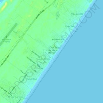
Name: Praia Santa Helena topographic map, elevation, terrain.
Average elevation: 5 m
Minimum elevation: 0 m
Maximum elevation: 19 m
Make a donation
Gear up for your next adventure:
As an Amazon Associate, this site earns from qualifying purchases at no extra cost to you.
Other topographic maps
Click on a map to view its topography, its elevation and its terrain.
Praia Grande
Brasil > Rio Grande do Sul > Aglomeração Urbana do Litoral Norte > Torres
Praia Grande é um município brasileiro do Estado de Santa Catarina. Localiza-se a uma latitude 29º11'48" sul e a uma longitude 49º57'01" oeste, estando a uma altitude de 45 metros. Sua população estimada em 2005 era de 7.102 habitantes.
Average elevation: 4 m
Praça João Neves da Fontoura
Brasil > Rio Grande do Sul > Aglomeração Urbana do Litoral Norte > Torres
Average elevation: 4 m
Parque Estadual José Lutzenberger
Brasil > Rio Grande do Sul > Aglomeração Urbana do Litoral Norte > Torres
Average elevation: 4 m
Praia de Itapeva
Brasil > Rio Grande do Sul > Aglomeração Urbana do Litoral Norte > Torres
Average elevation: 5 m
Make a donation
Gear up for your next adventure:
As an Amazon Associate, this site earns from qualifying purchases at no extra cost to you.
Praça Pedro Cardoso Duarte
Brasil > Rio Grande do Sul > Aglomeração Urbana do Litoral Norte > Torres
Average elevation: 5 m