Geolocate

Ranga topographic map

Click on the map to display elevation.

About this map

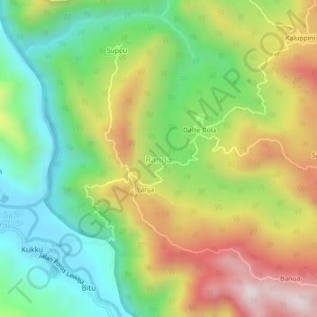
Name: Ranga topographic map, elevation, terrain.

Location: Ranga, Enrekang, South Sulawesi, Sulawesi, 91711, Indonesia (-3.57278 119.78604 -3.53278 119.82604)

Average elevation: 357 m

Minimum elevation: 52 m

Maximum elevation: 781 m

Other topographic maps

Click on a map to view its topography, its elevation and its terrain.

Baraka

Indonesia > South Sulawesi > Enrekang

Average elevation: 827 m

Bungin

Indonesia > South Sulawesi > Enrekang

Average elevation: 1,238 m

Malua

Indonesia > South Sulawesi > Enrekang

Average elevation: 709 m

Buntu Batu

Indonesia > South Sulawesi > Enrekang

Average elevation: 1,459 m

Cendana

Indonesia > South Sulawesi > Enrekang

Average elevation: 152 m

Maiwa

Indonesia > South Sulawesi > Enrekang

Average elevation: 214 m

Malua

Indonesia > South Sulawesi > Enrekang

Average elevation: 709 m

Alla

Indonesia > South Sulawesi > Enrekang

Average elevation: 1,037 m

Gear up for your next adventure:

🧢Outdoor Visor - Breathable visor for sunny hikes
🧦Hiking Liner Socks - Thin base layer to prevent friction and blisters
🧢Sun Hat - Wide-brim hat for sun protection
🧥Insulated Jacket - Keep warm in cold outdoor conditions
🧥Waterproof Pants - Keep dry during rainy hiking conditions

As an Amazon Associate, this site earns from qualifying purchases at no extra cost to you.