
Norland topographic map
Interactive map
Click on the map to display elevation.
About this map
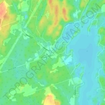
Name: Norland topographic map, elevation, terrain.
Average elevation: 269 m
Minimum elevation: 255 m
Maximum elevation: 297 m
Other topographic maps
Click on a map to view its topography, its elevation and its terrain.
Four Mile Lake
Canada > Ontario > Kawartha Lakes
Four Mile Lake, Kawartha Lakes, Central Ontario, Ontario, Canada
Average elevation: 282 m
Lindsay
Canada > Ontario > Kawartha Lakes
Lindsay, Kawartha Lakes, Central Ontario, Ontario, K9V 2Y5, Canada
Average elevation: 268 m
Kawartha Lakes
Canada > Ontario > Kawartha Lakes
Kawartha Lakes, Ontario, K9V 2W9, Canada
Average elevation: 269 m
Greenhurst-Thurstonia
Canada > Ontario > Kawartha Lakes
Greenhurst-Thurstonia, Kawartha Lakes, Central Ontario, Ontario, K0M 1L0, Canada
Average elevation: 263 m
Sturgeon Lake
Canada > Ontario > Kawartha Lakes
Sturgeon Lake, Kawartha Lakes, Central Ontario, Ontario, Canada
Average elevation: 266 m
Pigeon River
Canada > Ontario > Kawartha Lakes > Omemee
Pigeon River, Omemee, Kawartha Lakes, Central Ontario, Ontario, K0L 2W0, Canada
Average elevation: 259 m
Janetville
Canada > Ontario > Kawartha Lakes
Janetville, Kawartha Lakes, Central Ontario, Ontario, L0B 1K0, Canada
Average elevation: 276 m
Franklin
Canada > Ontario > Kawartha Lakes
Franklin, Kawartha Lakes, Central Ontario, Ontario, Canada
Average elevation: 283 m
Balsam Lake
Canada > Ontario > Kawartha Lakes
Balsam Lake, Maple Avenue, Kawartha Lakes, Ontario, Canada
Average elevation: 257 m
Bethany
Canada > Ontario > Kawartha Lakes
Bethany, Kawartha Lakes, Central Ontario, Ontario, Canada
Average elevation: 271 m
Young Lake
Canada > Ontario > Kawartha Lakes
Young Lake, Kawartha Lakes, Central Ontario, Ontario, Canada
Average elevation: 231 m
Carden Alvar Provincial Park
Canada > Ontario > Kawartha Lakes
Carden Alvar Provincial Park, Kawartha Lakes, Central Ontario, Ontario, Canada
Average elevation: 249 m
Bobcaygeon
Canada > Ontario > Kawartha Lakes
Bobcaygeon, Kawartha Lakes, Central Ontario, Ontario, K0M 1A0, Canada
Average elevation: 262 m
Dalrymple Lake
Canada > Ontario > Kawartha Lakes
Dalrymple Lake, Osprey Lane, Kawartha Lakes, Ontario, L0K 1W0, Canada
Average elevation: 241 m
View Lake
Canada > Ontario > Kawartha Lakes
View Lake, Kawartha Lakes, Central Ontario, Ontario, L0B 1K0, Canada
Average elevation: 257 m
Shadow Lake
Canada > Ontario > Kawartha Lakes
Shadow Lake, Kawartha Lakes, Central Ontario, Ontario, K0M 2L0, Canada
Average elevation: 266 m
Pontypool
Canada > Ontario > Kawartha Lakes
Pontypool, Kawartha Lakes, Central Ontario, Ontario, L0A 1K0, Canada
Average elevation: 344 m
Cambray
Canada > Ontario > Kawartha Lakes
Cambray, Kawartha Lakes, Central Ontario, Ontario, Canada
Average elevation: 270 m
Kawartha Lakes
Canada > Ontario > Kawartha Lakes
Kawartha Lakes, Central Ontario, Ontario, Canada
Average elevation: 274 m
Cameron Lake
Canada > Ontario > Kawartha Lakes > Fenelon Falls
Cameron Lake, Sugarbush Trail, Fenelon Falls, Kawartha Lakes, Ontario, K0M 1N0, Canada
Average elevation: 254 m
Head Lake
Canada > Ontario > Kawartha Lakes
Head Lake, Baker Boulevard, Kawartha Lakes, Central Ontario, Ontario, Canada
Average elevation: 278 m
Little Britain
Canada > Ontario > Kawartha Lakes
Little Britain, Kawartha Lakes, Central Ontario, Ontario, K0M 2C0, Canada
Average elevation: 262 m
Pigeon River
Canada > Ontario > Kawartha Lakes
Pigeon River, Kawartha Lakes, Ontario, Canada
Average elevation: 290 m
Omemee
Canada > Ontario > Kawartha Lakes
Omemee, Kawartha Lakes, Central Ontario, Ontario, K0L 2W0, Canada
Average elevation: 266 m
Scugog River
Canada > Ontario > Kawartha Lakes
Scugog River, Kawartha Lakes, Ontario, K9V 2L7, Canada
Average elevation: 264 m
Scugog River
Canada > Ontario > Kawartha Lakes > Lindsay
Scugog River, Lindsay, Kawartha Lakes, Central Ontario, Ontario, K9V 5R4, Canada
Average elevation: 264 m
Kirkfield
Canada > Ontario > Kawartha Lakes
Kirkfield, Kawartha Lakes, Central Ontario, Ontario, K0M 2B0, Canada
Average elevation: 269 m
Emily Provincial Park
Canada > Ontario > Kawartha Lakes
Emily Provincial Park, Parkview Court, Kawartha Lakes, Central Ontario, Ontario, K0L 2W0, Canada
Average elevation: 259 m
Coboconk
Canada > Ontario > Kawartha Lakes
Coboconk, Kawartha Lakes, Central Ontario, Ontario, K0M 1K0, Canada
Average elevation: 275 m
Balsam Lake
Canada > Ontario > Kawartha Lakes
Balsam Lake, Kawartha Lakes, Central Ontario, Ontario, Canada
Average elevation: 272 m
Oakwood
Canada > Ontario > Kawartha Lakes
Oakwood, Kawartha Lakes, Central Ontario, Ontario, K0M 2M0, Canada
Average elevation: 270 m
Woodville
Canada > Ontario > Kawartha Lakes
Woodville, Kawartha Lakes, Central Ontario, Ontario, K0M 2T0, Canada
Average elevation: 281 m
Long Beach
Canada > Ontario > Kawartha Lakes > Long Beach
Long Beach, Kawartha Lakes, Central Ontario, Ontario, K0M 1G0, Canada
Average elevation: 255 m
Cameron
Canada > Ontario > Kawartha Lakes
Cameron, Kawartha Lakes, Central Ontario, Ontario, K0M 1G0, Canada
Average elevation: 263 m
Gilson's Point
Canada > Ontario > Kawartha Lakes > Gilson's Point
Gilson's Point, Kawartha Lakes, Ontario, L9L 1B6, Canada
Average elevation: 258 m
Lorneville
Canada > Ontario > Kawartha Lakes
Lorneville, Kawartha Lakes, Central Ontario, Ontario, K0M 2T0, Canada
Average elevation: 276 m