Geolocate

Campo topographic map

Click on the map to display elevation.

About this map

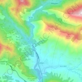
Name: Campo topographic map, elevation, terrain.

Location: Campo, Ribagorza, Huesca, Aragon, 22450, Spain (42.39267 0.36783 42.46581 0.42611)

Average elevation: 1,038 m

Minimum elevation: 655 m

Maximum elevation: 1,998 m

Other topographic maps

Click on a map to view its topography, its elevation and its terrain.

Undués Pintano

Spain > Aragon > Cinco Villas > Los Pintanos

Average elevation: 712 m

El Pueyo de Jaca

Spain > Aragon > Alto Gállego > Panticosa

Average elevation: 1,314 m

Aneto

Spain > Aragon > La Ribagorza > Benasque/Benás

Average elevation: 2,925 m

Lecina

Spain > Aragon > Sobrarbe > Bárcabo

Average elevation: 805 m

Gear up for your next adventure:

👟Trail Running Shoes - Agile footwear for fast-paced topographic exploration
🔭Compact Monocular - One-handed bird watching and trail spotting
🧦Merino Wool Socks - Moisture-wicking comfort for long-distance hiking
🧥Softshell Hiking Jacket - The perfect balance of wind protection and breathability
Family Camping Tent - Spacious tent suitable for family camping trips

As an Amazon Associate, this site earns from qualifying purchases at no extra cost to you.