Geolocate

Tena topographic map

Click on the map to display elevation.

About this map

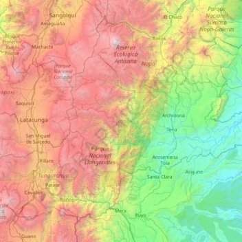
Name: Tena topographic map, elevation, terrain.

Location: Tena, Napo, Ecuador (-1.19352 -78.42726 -0.69421 -77.02697)

Average elevation: 2,299 m

Minimum elevation: 311 m

Maximum elevation: 5,786 m

Other topographic maps

Click on a map to view its topography, its elevation and its terrain.

Cóndor viewpoint

Ecuador > Napo > Archidona > Cotundo

Average elevation: 3,961 m

Largato Cocha

Ecuador > Napo > Tena > Pano

Average elevation: 610 m

Puntas

Ecuador > Napo > Quijos > Cuyuja

Average elevation: 3,913 m

El Chaco

Ecuador > Napo > Cantón El Chaco > El Chaco

Average elevation: 1,783 m

Guamani

Ecuador > Napo > Archidona

Average elevation: 1,145 m

Gear up for your next adventure:

🥾Waterproof Trail Shoes - Shoes designed to handle wet terrain
🧭GPS Handheld Device - Reliable GPS navigation for outdoor adventures
🧢Sun Hat - Wide-brim hat for sun protection
🎒Backpack Rain Cover - External shield to keep your entire pack dry
🧢Outdoor Visor - Breathable visor for sunny hikes

As an Amazon Associate, this site earns from qualifying purchases at no extra cost to you.