Geolocate

Guamani topographic map

Click on the map to display elevation.

About this map

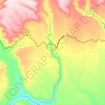
Name: Guamani topographic map, elevation, terrain.

Location: Guamani, Cotundo, Archidona, Napo, Ecuador (-0.76982 -77.65076 -0.68636 -77.63266)

Average elevation: 1,145 m

Minimum elevation: 776 m

Maximum elevation: 1,481 m

Other topographic maps

Click on a map to view its topography, its elevation and its terrain.

Cóndor viewpoint

Ecuador > Napo > Archidona > Cotundo

Average elevation: 3,961 m

Gear up for your next adventure:

🔨Vehicle Emergency Tool - Safety tool for remote road trips to trailheads
🔋Emergency Crank Radio - Weather alerts and power without needing batteries
🥾Trail Running Boots - Durable shoes designed for trail running
Family Camping Tent - Spacious tent suitable for family camping trips
🎒Hiking Backpack - Lightweight and ergonomic backpacks for day hikes or multi-day treks

As an Amazon Associate, this site earns from qualifying purchases at no extra cost to you.