Colwyn Bay topographic map
Interactive map
Click on the map to display elevation.
About this map
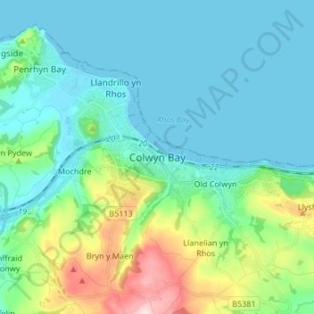
Name: Colwyn Bay topographic map, elevation, terrain.
Location: Colwyn Bay, Conwy, Wales, LL29 8GA, United Kingdom (53.25533 -3.76625 53.33533 -3.68625)
Average elevation: 68 m
Minimum elevation: 0 m
Maximum elevation: 332 m
Other topographic maps
Click on a map to view its topography, its elevation and its terrain.
Abergele
United Kingdom > Wales > Conwy
Abergele, Conwy, Wales, LL22 7BE, United Kingdom
Average elevation: 56 m
Llysfaen
United Kingdom > Wales > Conwy
Llysfaen, Conwy, Wales, LL29 8ST, United Kingdom
Average elevation: 76 m
Llandudno
United Kingdom > Wales > Conwy > Llandudno
Llandudno, Conwy, Wales, LL30 1AH, United Kingdom
Average elevation: 19 m
Dolwyddelan
United Kingdom > Wales > Conwy
Dolwyddelan, Conwy, Wales, LL25 0SQ, United Kingdom
Average elevation: 275 m