Geolocate

Mochdre topographic map

Click on the map to display elevation.

About this map

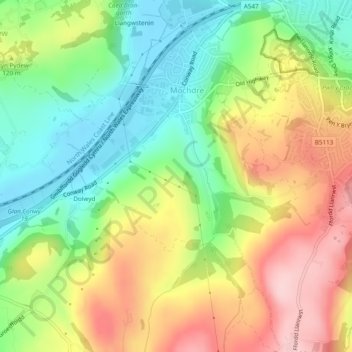
Name: Mochdre topographic map, elevation, terrain.

Location: Mochdre, Conwy, Wales, United Kingdom (53.27036 -3.77597 53.29913 -3.74638)

Average elevation: 98 m

Minimum elevation: 3 m

Maximum elevation: 219 m

Gear up for your next adventure:

🧢Beanie Hat - Keep your head warm in cold weather
🔦LED Flashlight - Powerful and long-lasting flashlight for camping and emergencies
🔋Solar Power Bank - Keep your GPS and devices charged during long outdoor trips
🧥Fleece Jacket - Warm and lightweight jacket for layering
🛁Quick-Dry Microfiber Towel - Space-saving towel that dries rapidly on the move

As an Amazon Associate, this site earns from qualifying purchases at no extra cost to you.