Geolocate

Ronceverte topographic map

Click on the map to display elevation.

About this map

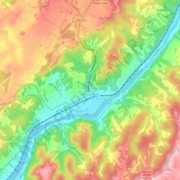
Name: Ronceverte topographic map, elevation, terrain.

Location: Ronceverte, Greenbrier County, West Virginia, 24970, United States (37.73675 -80.50367 37.76503 -80.44736)

Average elevation: 606 m

Minimum elevation: 495 m

Maximum elevation: 718 m

Other topographic maps

Click on a map to view its topography, its elevation and its terrain.

Anjean

United States > West Virginia > Greenbrier County

Average elevation: 971 m

Dawson

United States > West Virginia > Greenbrier County

Average elevation: 760 m

Clearco

United States > West Virginia > Greenbrier County

Average elevation: 1,129 m

Modoc

United States > West Virginia > Greenbrier County

Average elevation: 701 m

Duo

United States > West Virginia > Greenbrier County

Average elevation: 1,060 m

Alvon

United States > West Virginia > Greenbrier County > Alvon

Average elevation: 680 m

Gear up for your next adventure:

🧥Ultralight Puffy Jacket - Maximum warmth that packs down to the size of an orange
🔭Compact Monocular - One-handed bird watching and trail spotting
🥾Waterproof Trail Shoes - Shoes designed to handle wet terrain
🥾Waterproof Hiking Shoes - Durable shoes for wet and rugged trails
🥽Outdoor Goggles - Protective eyewear for outdoor activities

As an Amazon Associate, this site earns from qualifying purchases at no extra cost to you.