
Duo topographic map
Click on the map to display elevation.
About this map
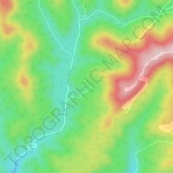
Name: Duo topographic map, elevation, terrain.
Location: Duo, Greenbrier County, West Virginia, United States (38.05123 -80.61759 38.09123 -80.57759)
Average elevation: 1,060 m
Minimum elevation: 929 m
Maximum elevation: 1,257 m
Other topographic maps
Click on a map to view its topography, its elevation and its terrain.
Alderson Recreation Area
United States > West Virginia > Greenbrier County > Alderson
Average elevation: 501 m