Geolocate

Lenhartzhammer topographic map

Click on the map to display elevation.

About this map
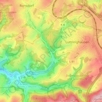
Name: Lenhartzhammer topographic map, elevation, terrain.

Location: Lenhartzhammer, Lüttringhausen, Remscheid, Noordrijn-Westfalen, 42899, Duitsland (51.18852 7.19412 51.22852 7.23412)

Average elevation: 280 m

Minimum elevation: 187 m

Maximum elevation: 369 m

Other topographic maps

Click on a map to view its topography, its elevation and its terrain.
Lennep

Duitsland > Noordrijn-Westfalen > Remscheid

Average elevation: 302 m

Gear up for your next adventure:

🧶550 Survival Paracord - Versatile utility cord for emergency repairs and rigging
🥾Lightweight Hiking Boots - Boots for comfort and mobility on long hikes
🥾Light Trekking Boots - Supportive boots for multi-day treks
🔋Solar Power Bank - Keep your GPS and devices charged during long outdoor trips
🧴Outdoor Sunscreen - High SPF protection for high-altitude UV exposure

As an Amazon Associate, this site earns from qualifying purchases at no extra cost to you.