Geolocate

Moorland topographic map

Click on the map to display elevation.

About this map

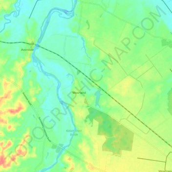
Name: Moorland topographic map, elevation, terrain.

Location: Moorland, Bundaberg Region, Queensland, 4670, Australia (-24.81350 152.16213 -24.71258 152.25317)

Average elevation: 21 m

Minimum elevation: -1 m

Maximum elevation: 59 m

Other topographic maps

Click on a map to view its topography, its elevation and its terrain.

Gin Gin

Australia > Queensland > Bundaberg Region > Gin Gin

Average elevation: 73 m

Isis River

Australia > Queensland > Bundaberg Region > Buxton

Average elevation: 12 m

Burrum River

Australia > Queensland > Bundaberg Region > Buxton

Average elevation: 20 m

Bundaberg

Australia > Queensland > Bundaberg Region

Average elevation: 18 m

Bundaberg

Australia > Queensland > Bundaberg Region

Average elevation: 18 m

Gear up for your next adventure:

🥽Outdoor Goggles - Protective eyewear for outdoor activities
🥾Waterproof Hiking Shoes - Durable shoes for wet and rugged trails
🐕Hiking Dog Pack - Let your canine companion carry their own water and food
💧Reusable Water Bottle - Durable water bottles for hydration on trails
🔦UV Flashlight - Detect minerals or specific insects in the dark

As an Amazon Associate, this site earns from qualifying purchases at no extra cost to you.