Geolocate

Pearisburg topographic map

Click on the map to display elevation.

About this map

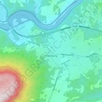
Name: Pearisburg topographic map, elevation, terrain.

Location: Pearisburg, Giles County, Virginia, United States (37.31401 -80.75946 37.34307 -80.70377)

Average elevation: 615 m

Minimum elevation: 464 m

Maximum elevation: 1,146 m

Other topographic maps

Click on a map to view its topography, its elevation and its terrain.

Kimballton

United States > Virginia > Giles County

Average elevation: 632 m

Midway

United States > Virginia > Giles County

Average elevation: 557 m

Gear up for your next adventure:

🚲Heavy Duty Bike Lock - Secure your bike at the trailhead or during stops
🎒Hiking Daypack - Lightweight and durable backpacks for day trips and excursions
🥾Hiking Boots - Sturdy boots providing ankle support and traction on rugged trails
🧥Softshell Hiking Jacket - The perfect balance of wind protection and breathability
🧦Thermal Socks - Warm socks for winter hiking or camping

As an Amazon Associate, this site earns from qualifying purchases at no extra cost to you.