Geolocate

Kimballton topographic map

Click on the map to display elevation.

About this map

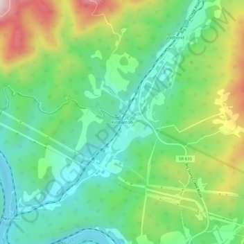
Name: Kimballton topographic map, elevation, terrain.

Location: Kimballton, Giles County, Virginia, 24150, United States (37.34623 -80.69729 37.38623 -80.65729)

Average elevation: 632 m

Minimum elevation: 467 m

Maximum elevation: 957 m

Other topographic maps

Click on a map to view its topography, its elevation and its terrain.

Pearisburg

United States > Virginia > Giles County

Average elevation: 615 m

New River

United States > Virginia > Giles County > Pembroke

Average elevation: 698 m

Narrows

United States > Virginia > Giles County

Average elevation: 531 m

Gear up for your next adventure:

🚲Handlebar Phone Mount - View topographic-map.com live while cycling
Camping Groundsheet - Protect your tent from moisture and dirt
🥾Hiking Shoes - Durable and comfortable shoes for trail hiking
🧥Softshell Hiking Jacket - The perfect balance of wind protection and breathability
🚑Survival Whistle - Signal for help across long distances in mountains

As an Amazon Associate, this site earns from qualifying purchases at no extra cost to you.