Geolocate

Midway topographic map

Click on the map to display elevation.

About this map

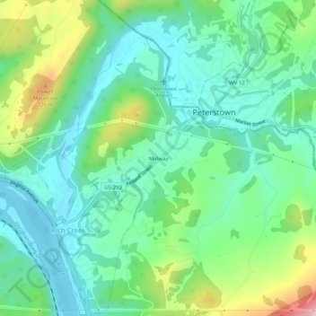
Name: Midway topographic map, elevation, terrain.

Location: Midway, Giles County, Virginia, 24147, United States (37.37151 -80.82813 37.41151 -80.78813)

Average elevation: 557 m

Minimum elevation: 452 m

Maximum elevation: 831 m

Other topographic maps

Click on a map to view its topography, its elevation and its terrain.

Pearisburg

United States > Virginia > Giles County

Average elevation: 615 m

New River

United States > Virginia > Giles County > Pembroke

Average elevation: 698 m

Narrows

United States > Virginia > Giles County

Average elevation: 531 m

Gear up for your next adventure:

🥾Mountain Hiking Shoes - Shoes with superior grip for mountainous terrain
💧Filtered Water Bottle - Safe drinking water on the go
🧭GPS Outdoor Watch - Smart watch for navigation and fitness tracking in nature
💡Solar Camping Lamp - Eco-friendly lighting for campsites
🥾Lightweight Hiking Shoes - Comfortable shoes for day hikes

As an Amazon Associate, this site earns from qualifying purchases at no extra cost to you.