
Oldsmar topographic map
Click on the map to display elevation.
Oldsmar
In 1921, a hurricane hit Tampa Bay. Because Oldsmar sits on a plateau with an elevation never rising over 20 feet (6.1 m) above sea level, it was devastated by the storm. Large trees were uprooted and floodwater reached levels 14 feet (4.3 m) above normal. Some of the homes that survived the storm were moved, by barge, to St. Petersburg in the following two decades.
About this map
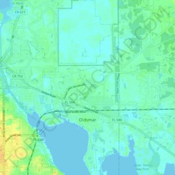
Name: Oldsmar topographic map, elevation, terrain.
Location: Oldsmar, Pinellas County, Florida, United States (28.00847 -82.71044 28.08956 -82.64850)
Average elevation: 6 m
Minimum elevation: -3 m
Maximum elevation: 23 m
Other topographic maps
Click on a map to view its topography, its elevation and its terrain.
Palm Harbor
United States > Florida > Pinellas County
Palm Harbor is characterized by its unique topography, which features a relatively rare hilly landscape for the region. Unlike much of the surrounding areas in Pinellas County, which are predominantly flat, Palm Harbor includes elevations that can reach up to about 75 feet above sea level. This elevation gives…
Average elevation: 9 m
Fort De Soto County Park
United States > Florida > Pinellas County > Saint Petersburg
Average elevation: 0 m
Saint Petersburg County Park
United States > Florida > Pinellas County > Saint Pete Beach
Average elevation: 1 m
Splash Harbour Water Park
United States > Florida > Pinellas County > Indian Rocks Beach
Average elevation: 4 m
Boyd Hill Nature Preserve
United States > Florida > Pinellas County > Saint Petersburg > Lakewood Estates
Average elevation: 7 m
Lealman
United States > Florida > Pinellas County
Lealman is located at 27°49′10″N 82°41′4″W / 27.81944°N 82.68444°W / 27.81944; -82.68444 (27.8197, -82.6846). The community is bordered by the city of Pinellas Park to the north, St. Petersburg to the east and south, and by the town of West Lealman to the west. The elevation is 49 feet (15…
Average elevation: 13 m
Boyd Hill Nature Preserve
United States > Florida > Pinellas County > Saint Petersburg > Lakewood Estates
Average elevation: 7 m
Acklocknayke (historical)
United States > Florida > Pinellas County > Palm Harbor
Average elevation: 3 m
Honeymoon Island Dog Beach
United States > Florida > Pinellas County > Palm Harbor
Average elevation: 0 m