Geolocate

Cold Fell topographic map

Click on the map to display elevation.

About this map

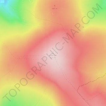
Name: Cold Fell topographic map, elevation, terrain.

Location: Cold Fell, Carlisle, Cumbria, North West England, England, CA8 2PN, United Kingdom (54.89384 -2.61631 54.89394 -2.61621)

Average elevation: 517 m

Minimum elevation: 296 m

Maximum elevation: 620 m

Other topographic maps

Click on a map to view its topography, its elevation and its terrain.

Dalston

United Kingdom > England > Cumbria > Carlisle

Average elevation: 90 m

Farlam

United Kingdom > England > Cumbria > Carlisle

Farlam was originally divided into two townships, East Farlam and West Farlam, with a combined population in 1811 of 672 inhabitants and 115 houses. Hallbankgate and Kirkhouse were two hamlets located within the township of East Farlam, the former four miles south east of Brampton, and the latter, where the…

Average elevation: 167 m

Nether Denton

United Kingdom > England > Cumbria > Carlisle

Average elevation: 175 m

River Eden

United Kingdom > England > Cumbria > Carlisle > Great Corby

Average elevation: 52 m

Trundley Wood

United Kingdom > England > Cumbria > Carlisle > Hethersgill

Average elevation: 51 m

Cumrew

United Kingdom > England > Cumbria > Carlisle

Average elevation: 289 m

Burtholme

United Kingdom > England > Cumbria > Carlisle

Average elevation: 82 m

Gear up for your next adventure:

🥽Outdoor Goggles - Protective eyewear for outdoor activities
🧦Hiking Liner Socks - Thin base layer to prevent friction and blisters
🥾Waterproof Hiking Boots - Boots keeping your feet dry in wet conditions
Camping Tent - Weather-resistant tents suitable for 2 to 6 people
💧Collapsible Water Bottle - Space-saving water bottle for outdoor activities

As an Amazon Associate, this site earns from qualifying purchases at no extra cost to you.