Geolocate

Los Baños del Inca topographic map

Click on the map to display elevation.

About this map

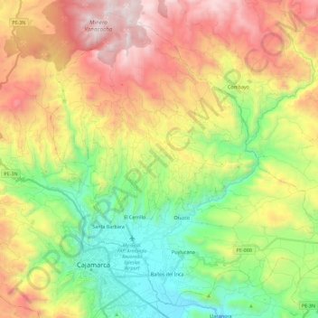
Name: Los Baños del Inca topographic map, elevation, terrain.

Location: Los Baños del Inca, Province of Cajamarca, Cajamarca, Peru (-7.18594 -78.54777 -6.97882 -78.32151)

Average elevation: 3,282 m

Minimum elevation: 2,612 m

Maximum elevation: 4,182 m

Other topographic maps

Click on a map to view its topography, its elevation and its terrain.

Callancas

Peru > Cajamarca > San Pablo

Average elevation: 3,024 m

Santa Cruz

Peru > Cajamarca

Average elevation: 511 m

El Cardon

Peru > Cajamarca > Cutervo

Average elevation: 2,316 m

Cruz De Chalpon

Peru > Cajamarca > San Ignacio

Average elevation: 1,488 m

Regalado

Peru > Cajamarca > Tumbaden

Average elevation: 3,304 m

Alto Otuzco

Peru > Cajamarca > Los Baños del Inca > Otuzco

Average elevation: 2,827 m

La Cordillera

Peru > Cajamarca > San Ignacio > La Cordillera

Average elevation: 1,361 m

Yube

Peru > Cajamarca > Callayuc

Average elevation: 1,589 m

Gear up for your next adventure:

👟Leg Gaiters - Keep debris, mud, and snow out of your boots
💧Filtered Water Bottle - Safe drinking water on the go
🧣Evaporative Cooling Towel - Beat the heat during intense summer climbs
🚲MTB Frame Bag - Carry tools and maps directly on your bicycle frame
🥫Freeze-Dried Meals - Lightweight, high-calorie nutrition for multi-day treks

As an Amazon Associate, this site earns from qualifying purchases at no extra cost to you.