
Make a donation
Gear up for your next adventure:
As an Amazon Associate, this site earns from qualifying purchases at no extra cost to you.
Wind Mountain topographic map
Click on the map to display elevation.
Make a donation
Gear up for your next adventure:
As an Amazon Associate, this site earns from qualifying purchases at no extra cost to you.
About this map
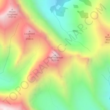
Name: Wind Mountain topographic map, elevation, terrain.
Average elevation: 2,550 m
Minimum elevation: 2,049 m
Maximum elevation: 3,136 m
Make a donation
Gear up for your next adventure:
As an Amazon Associate, this site earns from qualifying purchases at no extra cost to you.
Other topographic maps
Click on a map to view its topography, its elevation and its terrain.
Peter Lougheed Provincial Park
Canada > Alberta > Kananaskis Improvement District
Average elevation: 2,181 m
Bow Valley Provincial Park
Canada > Alberta > Kananaskis Improvement District
Average elevation: 1,705 m
West Bragg Creek Provincial Recreation Area
Canada > Alberta > Kananaskis Improvement District
Average elevation: 1,467 m
Make a donation
Gear up for your next adventure:
As an Amazon Associate, this site earns from qualifying purchases at no extra cost to you.
Make a donation
Gear up for your next adventure:
As an Amazon Associate, this site earns from qualifying purchases at no extra cost to you.