
Kananaskis River topographic map
Click on the map to display elevation.
About this map
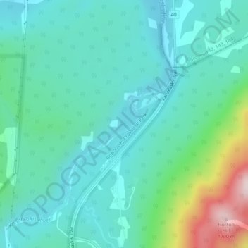
Name: Kananaskis River topographic map, elevation, terrain.
Average elevation: 1,395 m
Minimum elevation: 1,311 m
Maximum elevation: 1,714 m
Kananaskis Improvement District trails, hiking, mountain biking, running and outdoor activities
Other topographic maps
Click on a map to view its topography, its elevation and its terrain.
Peter Lougheed Provincial Park
Canada > Alberta > Kananaskis Improvement District
Average elevation: 2,181 m
Bow Valley Provincial Park
Canada > Alberta > Kananaskis Improvement District
Average elevation: 1,705 m
Mist Mountain
Canada > Alberta > Kananaskis Improvement District
Mist Mountain is a mountain located alongside Highway 40 in the Canadian Rockies of Alberta, Canada. It reaches an elevation of 3,140 m (10,300 ft) and is visible from Highway 40 and the Sheep River.
Average elevation: 2,515 m