
Radcot topographic map
Click on the map to display elevation.
About this map
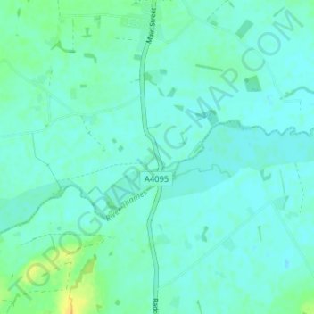
Name: Radcot topographic map, elevation, terrain.
Average elevation: 70 m
Minimum elevation: 65 m
Maximum elevation: 89 m
Other topographic maps
Click on a map to view its topography, its elevation and its terrain.
Hanborough
United Kingdom > England > Oxfordshire > West Oxfordshire > Church Hanborough
Average elevation: 83 m
Cassington
United Kingdom > England > Oxfordshire > West Oxfordshire > Cassington
Average elevation: 72 m
Stanton Harcourt
United Kingdom > England > Oxfordshire > West Oxfordshire > Stanton Harcourt
Average elevation: 67 m
Great Park
United Kingdom > England > Oxfordshire > West Oxfordshire > Long Hanborough
Average elevation: 94 m
Glympton
United Kingdom > England > Oxfordshire > West Oxfordshire > Glympton
Average elevation: 123 m
Great Tew
United Kingdom > England > Oxfordshire > West Oxfordshire > Great Tew
Average elevation: 157 m
Milton-under-Wychwood
United Kingdom > England > Oxfordshire > West Oxfordshire
Average elevation: 148 m
Ascott-under-Wychwood
United Kingdom > England > Oxfordshire > West Oxfordshire
Average elevation: 127 m
Minster Lovell
United Kingdom > England > Oxfordshire > West Oxfordshire > Minster Lovell
Average elevation: 112 m
Heythrop
United Kingdom > England > Oxfordshire > West Oxfordshire > Heythrop
Average elevation: 195 m
Little Faringdon
United Kingdom > England > Oxfordshire > West Oxfordshire > Little Faringdon
Average elevation: 80 m
South Leigh
United Kingdom > England > Oxfordshire > West Oxfordshire > South Leigh
Average elevation: 80 m
North Leigh
United Kingdom > England > Oxfordshire > West Oxfordshire > North Leigh
Average elevation: 108 m