Geolocate

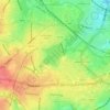
Bournville topographic map

Click on the map to display elevation.

About this map
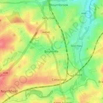
Name: Bournville topographic map, elevation, terrain.

Location: Bournville, Birmingham, West Midlands Combined Authority, England, B30 1LJ, United Kingdom (52.40718 -1.95646 52.44718 -1.91646)

Average elevation: 148 m

Minimum elevation: 113 m

Maximum elevation: 185 m

Other topographic maps

Click on a map to view its topography, its elevation and its terrain.
Sutton Coldfield

United Kingdom > England > Birmingham

Average elevation: 124 m

Sutton Park

United Kingdom > England > Birmingham > Four Oaks

Average elevation: 145 m

Lifford Reservoir

United Kingdom > England > Birmingham > Lifford

Average elevation: 150 m

Highbury Park

United Kingdom > England > Birmingham > Kings Heath

Average elevation: 142 m

Pype Hayes

United Kingdom > England > Birmingham > Tyburn

Average elevation: 104 m

North Edgbaston

United Kingdom > England > Birmingham

Average elevation: 162 m

Joy's Wood

United Kingdom > England > Birmingham > Wake Green

Average elevation: 140 m

Calthorpe Park

United Kingdom > England > Birmingham > Highgate

Average elevation: 128 m

Sutton Coldfield

United Kingdom > England > Birmingham

Average elevation: 124 m

Sutton Park

United Kingdom > England > Birmingham > Four Oaks

Average elevation: 145 m

Gear up for your next adventure:

🧥Packable Rain Jacket - Breathable waterproof layer for unpredictable weather
🗺️Topographic Maps - Detailed maps to explore trails, mountains, and wilderness areas
📷Outdoor Action Camera - Capture high-elevation views and rugged adventures
🧦Merino Wool Socks - Moisture-wicking comfort for long-distance hiking
🧼Biodegradable Camp Soap - Environmentally friendly cleaning for gear and body

As an Amazon Associate, this site earns from qualifying purchases at no extra cost to you.