Geolocate

Vazzola topographic map

Click on the map to display elevation.

About this map

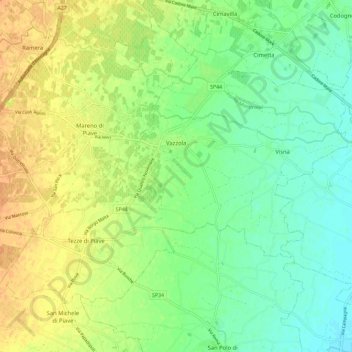
Name: Vazzola topographic map, elevation, terrain.

Location: Vazzola, Treviso, Veneto, 31028, Italy (45.80095 12.32061 45.85916 12.43589)

Average elevation: 29 m

Minimum elevation: 15 m

Maximum elevation: 46 m

Other topographic maps

Click on a map to view its topography, its elevation and its terrain.

Fanzolo

Italy > Veneto > Treviso > Vedelago

Average elevation: 60 m

Rover

Italy > Veneto > Treviso > Possagno > Possagno

Average elevation: 347 m

Colors

Italy > Veneto > Treviso > Fregona

Average elevation: 288 m

Le Marche

Italy > Veneto > Treviso > Breda di Piave > Le Marche

Average elevation: 17 m

Bigolino

Italy > Veneto > Treviso > Valdobbiadene > Bigolino

Average elevation: 168 m

Lovigioni

Italy > Veneto > Treviso > San Vito di Altivole

Average elevation: 82 m

Gear up for your next adventure:

🧥Softshell Jacket - Windproof and breathable jacket for hiking
🛌Down Sleeping Bag - Superior warmth-to-weight ratio for cold nights
🧭GPS Handheld Device - Reliable GPS navigation for outdoor adventures
🧥Waterproof Hiking Jacket - Protect yourself from rain and wind while hiking
🧥Waterproof Pants - Keep dry during rainy hiking conditions

As an Amazon Associate, this site earns from qualifying purchases at no extra cost to you.