Geolocate

Inverarity topographic map

Click on the map to display elevation.

About this map

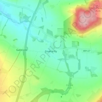
Name: Inverarity topographic map, elevation, terrain.

Location: Inverarity, Angus, Scotland, DD8 2JY, United Kingdom (56.56666 -2.91473 56.60666 -2.87473)

Average elevation: 125 m

Minimum elevation: 68 m

Maximum elevation: 257 m

Gear up for your next adventure:

🔪Outdoor Multitool - Versatile tool for repairs and food prep in the wild
🧭GPS Handheld Device - Reliable GPS navigation for outdoor adventures
🧥Insulated Jacket - Keep warm in cold outdoor conditions
🥾Lightweight Hiking Boots - Boots for comfort and mobility on long hikes
🧢Sun Hat - Wide-brim hat for sun protection

As an Amazon Associate, this site earns from qualifying purchases at no extra cost to you.