Geolocate

Mathira East topographic map

Click on the map to display elevation.

About this map

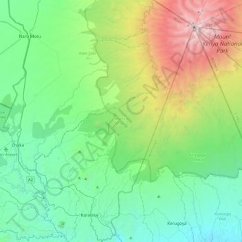
Name: Mathira East topographic map, elevation, terrain.

Location: Mathira East, Nyeri, Central Kenya, 10101, Kenya (-0.52931 37.02859 -0.10581 37.30854)

Average elevation: 2,282 m

Minimum elevation: 1,360 m

Maximum elevation: 5,029 m

Other topographic maps

Click on a map to view its topography, its elevation and its terrain.

Tyndall Glacier

Kenya > Nyeri

Average elevation: 4,526 m

Gear up for your next adventure:

🎒Fully Waterproof Backpack - Total protection for photography gear and electronics
📷Outdoor Action Camera - Capture high-elevation views and rugged adventures
🧥Softshell Jacket - Windproof and breathable jacket for hiking
🧰Emergency Multi-Tool - Compact multi-tool for outdoor survival
🛶Kayak Dry Bag - Waterproof storage for kayaking adventures

As an Amazon Associate, this site earns from qualifying purchases at no extra cost to you.