Geolocate

Pecksburg topographic map

Click on the map to display elevation.

About this map

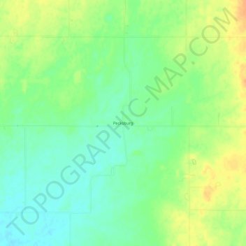
Name: Pecksburg topographic map, elevation, terrain.

Location: Pecksburg, Hendricks County, Indiana, 46103, United States (39.66810 -86.59417 39.70810 -86.55417)

Average elevation: 256 m

Minimum elevation: 241 m

Maximum elevation: 273 m

Other topographic maps

Click on a map to view its topography, its elevation and its terrain.

North Salem

United States > Indiana > Hendricks County

Average elevation: 278 m

Stilesville

United States > Indiana > Hendricks County

Average elevation: 240 m

Coatesville

United States > Indiana > Hendricks County

Average elevation: 271 m

Pittsboro

United States > Indiana > Hendricks County

Average elevation: 285 m

Amo

United States > Indiana > Hendricks County

Average elevation: 255 m

Avon

United States > Indiana > Hendricks County

Average elevation: 254 m

Danville

United States > Indiana > Hendricks County

Average elevation: 281 m

Clayton

United States > Indiana > Hendricks County

Average elevation: 263 m

Lizton

United States > Indiana > Hendricks County

Average elevation: 292 m

Gear up for your next adventure:

🥾Approach Boots - Comfortable boots for hiking and climbing approaches
💡LED Camping Lantern - Illuminate your campsite with long-lasting lanterns
🥘Camping Cookware Set - Compact nesting pots and pans for trail cooking
🧥Ultralight Puffy Jacket - Maximum warmth that packs down to the size of an orange
🧦Merino Wool Socks - Moisture-wicking comfort for long-distance hiking

As an Amazon Associate, this site earns from qualifying purchases at no extra cost to you.