
Make a donation
Gear up for your next adventure:
As an Amazon Associate, this site earns from qualifying purchases at no extra cost to you.
Neipel topographic map
Click on the map to display elevation.
Make a donation
Gear up for your next adventure:
As an Amazon Associate, this site earns from qualifying purchases at no extra cost to you.
About this map
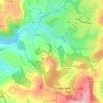
Name: Neipel topographic map, elevation, terrain.
Location: Neipel, Tholey, Landkreis St. Wendel, Saarland, Deutschland (49.46867 6.91160 49.48708 6.93694)
Average elevation: 345 m
Minimum elevation: 256 m
Maximum elevation: 451 m
Make a donation
Gear up for your next adventure:
As an Amazon Associate, this site earns from qualifying purchases at no extra cost to you.
Other topographic maps
Click on a map to view its topography, its elevation and its terrain.
Bostalsee
Deutschland > Saarland > Landkreis St. Wendel > Nohfelden
Wegen der Bauwerkshöhe des Sperrdamms von mehr als fünf Metern über Talgrund gilt der Bostalsee juristisch und technisch als Talsperre und wird entsprechend durch die Erlaubnisbehören überwacht. Gemäß der Nomenklatur müsste sie als Bosbachtalsperre oder Talsperre Bosen bezeichnet werden.
Average elevation: 412 m
Make a donation
Gear up for your next adventure:
As an Amazon Associate, this site earns from qualifying purchases at no extra cost to you.
Make a donation
Gear up for your next adventure:
As an Amazon Associate, this site earns from qualifying purchases at no extra cost to you.
Schaumberg
Deutschland > Saarland > Landkreis St. Wendel > Tholey
Der Schaumberg ist ein Berg im Saarland und die höchste Erhebung im Naturraum Prims-Blies-Hügelland. Der Berg ist ein Kegelberg vulkanischen Ursprungs. Mit einer Höhe von 568,2 m und dem aufgesetzten markanten Schaumbergturm ist er aus weiter Entfernung sichtbar und gilt als „Hausberg des Saarlandes“,…
Average elevation: 405 m
Make a donation
Gear up for your next adventure:
As an Amazon Associate, this site earns from qualifying purchases at no extra cost to you.
Schwarzenbach-Ziegelhütte
Deutschland > Saarland > Landkreis St. Wendel > Nonnweiler
Average elevation: 469 m