
Make a donation
Gear up for your next adventure:
As an Amazon Associate, this site earns from qualifying purchases at no extra cost to you.
Ritzenberg topographic map
Click on the map to display elevation.
Make a donation
Gear up for your next adventure:
As an Amazon Associate, this site earns from qualifying purchases at no extra cost to you.
About this map
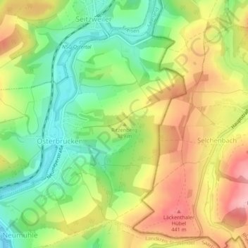
Name: Ritzenberg topographic map, elevation, terrain.
Average elevation: 375 m
Minimum elevation: 300 m
Maximum elevation: 460 m
Make a donation
Gear up for your next adventure:
As an Amazon Associate, this site earns from qualifying purchases at no extra cost to you.
Other topographic maps
Click on a map to view its topography, its elevation and its terrain.
Make a donation
Gear up for your next adventure:
As an Amazon Associate, this site earns from qualifying purchases at no extra cost to you.
Leitersweiler
Deutschland > Saarland > Landkreis St. Wendel > Sankt Wendel
Leitersweiler liegt etwa 5 Kilometer ostnordöstlich von St. Wendel unterhalb der sogenannten Leitersweiler Buchen auf einer Höhe von 420 Meter über NN in einem Nebental des oberen Betzelbaches. Der Ort liegt in einem Kessel, so dass er aus der Ferne so gut wie nicht zu sehen ist. Nach Westen hin befinden…
Average elevation: 392 m
Werschweiler
Deutschland > Saarland > Landkreis St. Wendel > Sankt Wendel
In Werschweiler werden die sehr alten Brauchtümer des Maisingens und des Pfingstquacks gepflegt. Beim Maisingen tragen die Konfirmandinnen (heute natürlich auch Kinder anderer Konfessionen bzw. Glaubensrichtungen im entsprechenden Alter) des langjährig protestantisch geprägten Dorfes am ersten Mai einen…
Average elevation: 344 m