Geolocate

Brimfield topographic map

Click on the map to display elevation.

About this map

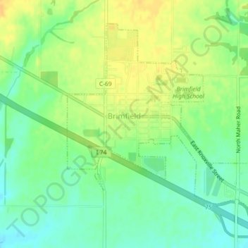
Name: Brimfield topographic map, elevation, terrain.

Location: Brimfield, Peoria County, Illinois, United States (40.82711 -89.89473 40.84897 -89.86568)

Average elevation: 213 m

Minimum elevation: 199 m

Maximum elevation: 226 m

Other topographic maps

Click on a map to view its topography, its elevation and its terrain.

Monica

United States > Illinois > Peoria County

Average elevation: 230 m

Kickapoo

United States > Illinois > Peoria County

Average elevation: 198 m

Trivoli

United States > Illinois > Peoria County

Average elevation: 224 m

Peoria

United States > Illinois > Peoria County > Peoria

Average elevation: 196 m

Gear up for your next adventure:

💧Filtered Water Bottle - Safe drinking water on the go
🧣Merino Neck Gaiter - Protects against wind, sun, and cold at high altitudes
🥾Trail Running Boots - Durable shoes designed for trail running
🥾Hiking Boots - Sturdy boots providing ankle support and traction on rugged trails
🧦Hiking Socks - Moisture-wicking and comfortable socks for long hikes

As an Amazon Associate, this site earns from qualifying purchases at no extra cost to you.