Geolocate

Maple Grove topographic map

Click on the map to display elevation.

About this map

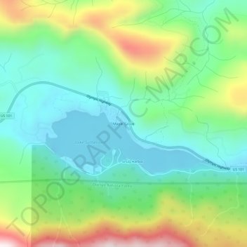
Name: Maple Grove topographic map, elevation, terrain.

Location: Maple Grove, Clallam County, Washington, United States (48.06120 -123.72520 48.10120 -123.68520)

Average elevation: 385 m

Minimum elevation: 147 m

Maximum elevation: 894 m

Other topographic maps

Click on a map to view its topography, its elevation and its terrain.

Port Angeles

United States > Washington > Clallam County

Port Angeles is characterized by a diverse and dramatic topography that reflects its unique geographic position on the Olympic Peninsula. Situated at approximately 72 feet above sea level, the city rises from the shores of the Strait of Juan de Fuca and is bordered by the Olympic Mountains to the south, which…

Average elevation: 27 m

Sequim

United States > Washington > Clallam County

Average elevation: 88 m

Forks

United States > Washington > Clallam County

Average elevation: 113 m

Carlsborg

United States > Washington > Clallam County

Average elevation: 73 m

Sequim

United States > Washington > Clallam County

Average elevation: 88 m

Forks

United States > Washington > Clallam County

Average elevation: 113 m

Neah Bay

United States > Washington > Clallam County

Average elevation: 72 m

Hoko River

United States > Washington > Clallam County

Average elevation: 207 m

Gear up for your next adventure:

🧭GPS Tracker - Track your location in remote areas safely
🧥Waterproof Jacket - Lightweight rain jackets for hiking and outdoor activities
🔥Emergency Fire Starter - Reliable ignition source for all weather conditions
🔦LED Flashlight - Powerful and long-lasting flashlight for camping and emergencies
🧤Rechargeable Heated Gloves - Extreme warmth for Canadian winter expeditions

As an Amazon Associate, this site earns from qualifying purchases at no extra cost to you.