Geolocate

Nolin topographic map

Click on the map to display elevation.

About this map

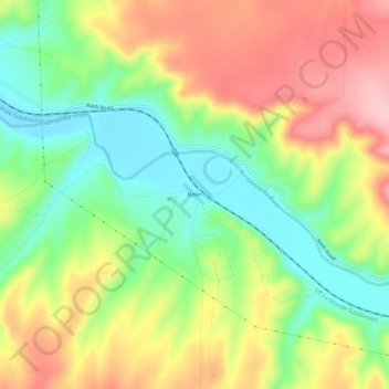
Name: Nolin topographic map, elevation, terrain.

Location: Nolin, Umatilla County, Oregon, United States (45.66306 -119.12092 45.70306 -119.08092)

Average elevation: 295 m

Minimum elevation: 216 m

Maximum elevation: 386 m

Other topographic maps

Click on a map to view its topography, its elevation and its terrain.

Hermiston

United States > Oregon > Umatilla County

Average elevation: 160 m

Ukiah

United States > Oregon > Umatilla County

Average elevation: 1,030 m

Pendleton

United States > Oregon > Umatilla County

Average elevation: 402 m

Umatilla

United States > Oregon > Umatilla County

Average elevation: 142 m

Pilot Rock

United States > Oregon > Umatilla County

Average elevation: 527 m

Wallula Gap

United States > Oregon > Umatilla County

Average elevation: 313 m

Pendleton

United States > Oregon > Umatilla County

Average elevation: 402 m

Echo

United States > Oregon > Umatilla County

Average elevation: 212 m

Pendleton

United States > Oregon > Umatilla County

Average elevation: 402 m

Weston

United States > Oregon > Umatilla County

Average elevation: 595 m

Gear up for your next adventure:

🦶Hiking Shoe Insoles - Added support for high arches and long days on feet
🧢Beanie Hat - Keep your head warm in cold weather
🔋Lithium AA Batteries - Long-lasting power that performs in extreme cold
🥾Hiking Gaiters - Protect legs and shoes from mud, snow, and debris
🔦LED Headlamp - Hands-free lighting for early morning starts or late finishes

As an Amazon Associate, this site earns from qualifying purchases at no extra cost to you.