Geolocate

Umatilla topographic map

Click on the map to display elevation.

About this map

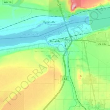
Name: Umatilla topographic map, elevation, terrain.

Location: Umatilla, Umatilla County, Oregon, United States (45.87912 -119.36971 45.93016 -119.22384)

Average elevation: 142 m

Minimum elevation: 79 m

Maximum elevation: 282 m

Other topographic maps

Click on a map to view its topography, its elevation and its terrain.

Tollgate

United States > Oregon > Umatilla County

Average elevation: 1,512 m

Myrick

United States > Oregon > Umatilla County

Average elevation: 535 m

Meacham

United States > Oregon > Umatilla County

Average elevation: 1,166 m

Nolin

United States > Oregon > Umatilla County

Average elevation: 295 m

Wallula Gap

United States > Oregon > Umatilla County

Average elevation: 313 m

Gear up for your next adventure:

🧰Multitool Knife - Compact and versatile tool for outdoor use
🥾Hiking Shorts - Breathable shorts suitable for summer hikes
🔥Emergency Fire Starter - Reliable ignition source for all weather conditions
💧Filtered Water Bottle - Safe drinking water on the go
🧦Crew Hiking Socks - Comfortable socks for long-distance hikes

As an Amazon Associate, this site earns from qualifying purchases at no extra cost to you.