Geolocate

Pendleton topographic map

Click on the map to display elevation.

About this map

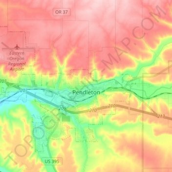
Name: Pendleton topographic map, elevation, terrain.

Location: Pendleton, Umatilla County, Oregon, 97801, United States (45.63972 -118.88186 45.71107 -118.74981)

Average elevation: 402 m

Minimum elevation: 299 m

Maximum elevation: 481 m

Other topographic maps

Click on a map to view its topography, its elevation and its terrain.

Tollgate

United States > Oregon > Umatilla County

Average elevation: 1,512 m

Myrick

United States > Oregon > Umatilla County

Average elevation: 535 m

Meacham

United States > Oregon > Umatilla County

Average elevation: 1,166 m

Nolin

United States > Oregon > Umatilla County

Average elevation: 295 m

Wallula Gap

United States > Oregon > Umatilla County

Average elevation: 313 m

Gear up for your next adventure:

🦌Outdoor Trail Camera - Monitor wildlife activity near your favorite spots
🚲MTB Frame Bag - Carry tools and maps directly on your bicycle frame
🧥Softshell Jacket - Windproof and breathable jacket for hiking
🪑Insulated Seat Pad - Protect your seat from cold rocks and wet logs
🧦Hiking Liner Socks - Thin base layer to prevent friction and blisters

As an Amazon Associate, this site earns from qualifying purchases at no extra cost to you.