Geolocate

Forallac topographic map

Click on the map to display elevation.

About this map
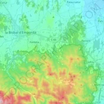
Name: Forallac topographic map, elevation, terrain.

Location: Forallac, Bajo Ampurdán, Gerona, Cataluña, España (41.88893 3.04365 41.99174 3.12726)

Average elevation: 107 m

Minimum elevation: 0 m

Maximum elevation: 424 m

Other topographic maps

Click on a map to view its topography, its elevation and its terrain.

sa Riera

España > Cataluña > Bajo Ampurdán > Begur

Average elevation: 66 m

Valldevià

España > Cataluña > Bajo Ampurdán > Vilopriu

Average elevation: 96 m

Fonolleres

España > Cataluña > Bajo Ampurdán > Parlavà

Average elevation: 20 m

Vulpellac

España > Cataluña > Bajo Ampurdán > Forallac

Average elevation: 57 m

Pals

España > Cataluña > Bajo Ampurdán > Pals > Pals

Average elevation: 34 m

Peratallada

España > Cataluña > Bajo Ampurdán > Forallac

Average elevation: 44 m

Fonteta

España > Cataluña > Bajo Ampurdán > Forallac

Average elevation: 77 m

Llafranc

España > Cataluña > Bajo Ampurdán > Palafrugell

Average elevation: 38 m

Puig de Terme

España > Cataluña > Bajo Ampurdán > Mont-ras

Average elevation: 28 m

Fornells

España > Cataluña > Bajo Ampurdán > Begur

Average elevation: 81 m

Púbol

España > Cataluña > Bajo Ampurdán

Average elevation: 112 m

Cap de Begur

España > Cataluña > Bajo Ampurdán > Begur

Average elevation: 39 m

Illa Roja

España > Cataluña > Bajo Ampurdán > Begur

Average elevation: 49 m

sa Riera

España > Cataluña > Bajo Ampurdán > Begur

Average elevation: 66 m

Gear up for your next adventure:

🧊Portable Cooler - Keep food and drinks cold during outdoor adventures
🐕Hiking Dog Pack - Let your canine companion carry their own water and food
🔦LED Flashlight - Powerful and long-lasting flashlight for camping and emergencies
🔭Compact Binoculars - Lightweight optics for scouting trails and wildlife
🛶Kayak Dry Bag - Waterproof storage for kayaking adventures

As an Amazon Associate, this site earns from qualifying purchases at no extra cost to you.