Geolocate

Blaenavon topographic map

Click on the map to display elevation.

About this map
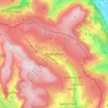
Name: Blaenavon topographic map, elevation, terrain.

Location: Blaenavon, Torfaen, Wales, NP4 9EJ, United Kingdom (51.73282 -3.12438 51.81282 -3.04438)

Average elevation: 383 m

Minimum elevation: 44 m

Maximum elevation: 575 m

Other topographic maps

Click on a map to view its topography, its elevation and its terrain.

Abersychan

United Kingdom > Wales > Torfaen

Average elevation: 334 m

Trevethin

United Kingdom > Wales > Torfaen > Pontypool

Average elevation: 228 m

Croesyceiliog

United Kingdom > Wales > Torfaen

Average elevation: 83 m

Cwmbran

United Kingdom > Wales > Torfaen

Average elevation: 88 m

New Inn

United Kingdom > Wales > Torfaen > Pontypool

Average elevation: 141 m

Pontnewydd

United Kingdom > Wales > Torfaen

Average elevation: 100 m

Henllys

United Kingdom > Wales > Torfaen

Average elevation: 172 m

Upper Cwmbran

United Kingdom > Wales > Torfaen > Cwmbran

Average elevation: 236 m

Pontypool Park

United Kingdom > Wales > Torfaen > Pontypool

Average elevation: 162 m

Ponthir

United Kingdom > Wales > Torfaen

Average elevation: 48 m

Pontymoile

United Kingdom > Wales > Torfaen > Pontypool

Average elevation: 157 m

New Inn

United Kingdom > Wales > Torfaen > Pontypool

Average elevation: 141 m

New Inn

United Kingdom > Wales > Torfaen > Pontypool

Average elevation: 141 m

Gear up for your next adventure:

🔨Vehicle Emergency Tool - Safety tool for remote road trips to trailheads
🥤Collapsible Travel Cup - Saves space and weight in your mess kit
🔋Lithium AA Batteries - Long-lasting power that performs in extreme cold
🦶Hiking Shoe Insoles - Added support for high arches and long days on feet
🥾Trekking Poles - Adjustable trekking poles to reduce knee stress and improve stability

As an Amazon Associate, this site earns from qualifying purchases at no extra cost to you.