Geolocate

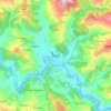
Shikhar topographic map

Click on the map to display elevation.

About this map

Name: Shikhar topographic map, elevation, terrain.

Location: Shikhar, Doti, Sudurpashchim Province, Nepal (29.12664 80.70182 29.36367 80.92939)

Average elevation: 1,488 m

Minimum elevation: 511 m

Maximum elevation: 2,736 m

Other topographic maps

Click on a map to view its topography, its elevation and its terrain.
Silgadhi

Nepal > Sudurpashchim Province > Doti

Average elevation: 1,129 m

Dipayal

Nepal > Sudurpashchim Province > Doti

Average elevation: 832 m

Silgadhi

Nepal > Sudurpashchim Province > Doti

Average elevation: 1,129 m

Gear up for your next adventure:

🔭Compact Monocular - One-handed bird watching and trail spotting
🥾Waterproof Trail Shoes - Shoes designed to handle wet terrain
🥾Hiking Leggings - Comfortable leggings for outdoor activities
🩹Moleskin Blister Pads - Direct protection for painful foot pressure points
🦌Outdoor Trail Camera - Monitor wildlife activity near your favorite spots

As an Amazon Associate, this site earns from qualifying purchases at no extra cost to you.