Geolocate

Dipayal topographic map

Click on the map to display elevation.

About this map

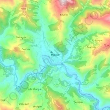
Name: Dipayal topographic map, elevation, terrain.

Location: Dipayal, Dipayal Silgadi, Doti, Sudurpashchim Province, Nepal (29.22013 80.89924 29.30013 80.97924)

Average elevation: 832 m

Minimum elevation: 495 m

Maximum elevation: 1,589 m

Other topographic maps

Click on a map to view its topography, its elevation and its terrain.

Shikhar

Nepal > Sudurpashchim Province > Doti

Average elevation: 1,488 m

Gear up for your next adventure:

🥾Mountain Trail Shoes - High-traction shoes for mountain trails
🗺️Topographic Maps - Detailed maps to explore trails, mountains, and wilderness areas
🧴Insect Repellent - Protect yourself from bugs during outdoor adventures
🧢Sun Hat - Wide-brim hat for sun protection
🧢Hiking Hat - Sun-protective and breathable hats for long treks

As an Amazon Associate, this site earns from qualifying purchases at no extra cost to you.