
Theddingworth topographic map
Click on the map to display elevation.
About this map
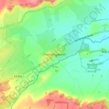
Name: Theddingworth topographic map, elevation, terrain.
Average elevation: 122 m
Minimum elevation: 93 m
Maximum elevation: 173 m
Other topographic maps
Click on a map to view its topography, its elevation and its terrain.
Adrian's Spinney
United Kingdom > England > Leicestershire > Harborough > Stoughton
Average elevation: 113 m
Great Glen
United Kingdom > England > Leicestershire > Harborough > Great Glen
Average elevation: 115 m
South Kilworth
United Kingdom > England > Leicestershire > Harborough > South Kilworth
Average elevation: 134 m
Broughton Astley
United Kingdom > England > Leicestershire > Harborough > Broughton Astley
Average elevation: 87 m
Kimcote and Walton
United Kingdom > England > Leicestershire > Harborough > Kimcote and Walton
Average elevation: 144 m
Saddington
United Kingdom > England > Leicestershire > Harborough > Saddington
Average elevation: 127 m
Little Stretton
United Kingdom > England > Leicestershire > Harborough > Little Stretton
Average elevation: 132 m
Claybrooke Magna
United Kingdom > England > Leicestershire > Harborough > Claybrooke Magna
Average elevation: 102 m
Stonton Wyville
United Kingdom > England > Leicestershire > Harborough > Stonton Wyville
Average elevation: 113 m
Burton Overy
United Kingdom > England > Leicestershire > Harborough > Burton Overy
Average elevation: 126 m
Saddington Reservoir
United Kingdom > England > Leicestershire > Harborough > Saddington
Average elevation: 128 m
Smeeton Westerby
United Kingdom > England > Leicestershire > Harborough > Smeeton Westerby
Average elevation: 112 m
Bruntingthorpe
United Kingdom > England > Leicestershire > Harborough > Bruntingthorpe
Average elevation: 132 m
Dunton Bassett
United Kingdom > England > Leicestershire > Harborough > Dunton Bassett
Average elevation: 115 m
Husbands Bosworth
United Kingdom > England > Leicestershire > Harborough > Husbands Bosworth
Average elevation: 142 m