Geolocate

Atessa topographic map

Click on the map to display elevation.

About this map

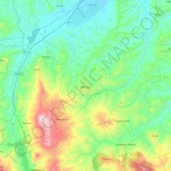
Name: Atessa topographic map, elevation, terrain.

Location: Atessa, Chieti, Abruzzo, 66041, Italy (41.98464 14.35776 42.16204 14.55369)

Average elevation: 305 m

Minimum elevation: 40 m

Maximum elevation: 1,011 m

Other topographic maps

Click on a map to view its topography, its elevation and its terrain.

Vallone di Santo Spirito

Italy > Abruzzo > Chieti > Fara San Martino

Average elevation: 1,273 m

Buonanotte

Italy > Abruzzo > Chieti > Vasto

Average elevation: 43 m

Fallascoso

Italy > Abruzzo > Chieti > Torricella Peligna

Average elevation: 839 m

Casali

Italy > Abruzzo > Chieti > Schiavi di Abruzzo

Average elevation: 734 m

Coderuto

Italy > Abruzzo > Chieti > Torrevecchia Teatina

Average elevation: 77 m

Foro

Italy > Abruzzo > Chieti > Miglianico

Average elevation: 143 m

Aquilano

Italy > Abruzzo > Chieti > Ortona > Aquilano

Average elevation: 86 m

Gear up for your next adventure:

🚲Heavy Duty Bike Lock - Secure your bike at the trailhead or during stops
🔦UV Flashlight - Detect minerals or specific insects in the dark
🎒Hiking Daypack - Lightweight and durable backpacks for day trips and excursions
🦌Outdoor Trail Camera - Monitor wildlife activity near your favorite spots
🥾Approach Boots - Comfortable boots for hiking and climbing approaches

As an Amazon Associate, this site earns from qualifying purchases at no extra cost to you.