Geolocate

Newfield topographic map

Click on the map to display elevation.

About this map
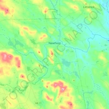
Name: Newfield topographic map, elevation, terrain.

Location: Newfield, York County, Maine, 04095, United States (43.59507 -70.97934 43.67538 -70.81124)

Average elevation: 157 m

Minimum elevation: 91 m

Maximum elevation: 320 m

Other topographic maps

Click on a map to view its topography, its elevation and its terrain.

Boon Island

United States > Maine > York County > York

Average elevation: 0 m

Lake Sherburne

United States > Maine > York County > Waterboro

Average elevation: 142 m

Wells Beach

United States > Maine > York County > Wells

Average elevation: 1 m

Jamaica Island

United States > Maine > York County > Kittery

Average elevation: 31 m

Parsons Beach

United States > Maine > York County > Kennebunk

Average elevation: 3 m

Crescent Beach

United States > Maine > York County > Kittery

Average elevation: 5 m

Rotary Park

United States > Maine > York County > Kennebunk > Kennebunk

Average elevation: 18 m

Mount Agamenticus

United States > Maine > York County > York

Average elevation: 92 m

Boon Island

United States > Maine > York County > York

Average elevation: 0 m

Mount Agamenticus

United States > Maine > York County > York

Average elevation: 92 m

Rotary Park

United States > Maine > York County > Kennebunk > Kennebunk

Average elevation: 18 m

Ogunquit Beach

United States > Maine > York County > Ogunquit

Average elevation: 11 m

Holdsworth Park

United States > Maine > York County > Sanford

Average elevation: 130 m

Gear up for your next adventure:

🥾Durable Hiking Shoes - Long-lasting shoes for frequent hiking
🧰Multitool Knife - Compact and versatile tool for outdoor use
🥾Hiking Shoes - Durable and comfortable shoes for trail hiking
🐕Hiking Dog Pack - Let your canine companion carry their own water and food
🥾Trail Hiking Shoes - Durable shoes designed for rugged trails

As an Amazon Associate, this site earns from qualifying purchases at no extra cost to you.