
Make a donation
Gear up for your next adventure:
As an Amazon Associate, this site earns from qualifying purchases at no extra cost to you.
Genesee County topographic map
Click on the map to display elevation.
Make a donation
Gear up for your next adventure:
As an Amazon Associate, this site earns from qualifying purchases at no extra cost to you.
About this map
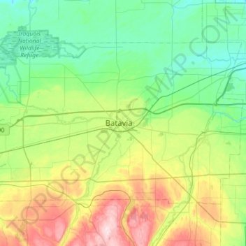
Name: Genesee County topographic map, elevation, terrain.
Location: Genesee County, New York, United States (42.86277 -78.46543 43.13304 -77.90418)
Average elevation: 269 m
Minimum elevation: 166 m
Maximum elevation: 554 m
Make a donation
Gear up for your next adventure:
As an Amazon Associate, this site earns from qualifying purchases at no extra cost to you.
Other topographic maps
Click on a map to view its topography, its elevation and its terrain.
Troy
United States > New York > Rensselaer County
The western edge of the city is flat along the river, and then steeply slopes to higher terrain to the east. The average elevation is 50 feet, with the highest elevation being 500 feet in the eastern part of the city. The city is longer than it is wide, with the southern part wider than the northern section of…
Average elevation: 137 m
Saratoga Springs
United States > New York > Saratoga County > Saratoga Springs
Average elevation: 161 m
Farmersville Station
United States > New York > Cattaraugus County > Town of Farmersville
Average elevation: 563 m
Make a donation
Gear up for your next adventure:
As an Amazon Associate, this site earns from qualifying purchases at no extra cost to you.
East Hampton
United States > New York > Suffolk County > East Hampton > Village of East Hampton
Average elevation: 12 m
Make a donation
Gear up for your next adventure:
As an Amazon Associate, this site earns from qualifying purchases at no extra cost to you.
Make a donation
Gear up for your next adventure:
As an Amazon Associate, this site earns from qualifying purchases at no extra cost to you.
Make a donation
Gear up for your next adventure:
As an Amazon Associate, this site earns from qualifying purchases at no extra cost to you.
Make a donation
Gear up for your next adventure:
As an Amazon Associate, this site earns from qualifying purchases at no extra cost to you.
Make a donation
Gear up for your next adventure:
As an Amazon Associate, this site earns from qualifying purchases at no extra cost to you.
Erie Canal
United States > New York > Erie County > City of Tonawanda
The construction of the Erie Canal was a landmark civil engineering achievement in the early history of the United States. When built, the 363-mile (584 km) canal was the second-longest in the world (after the Grand Canal in China). Initially 40 feet (12 m) wide and 4 feet (1.2 m) deep, the canal was expanded…
Average elevation: 177 m
Make a donation
Gear up for your next adventure:
As an Amazon Associate, this site earns from qualifying purchases at no extra cost to you.
Sag Harbor
United States > New York > Suffolk County > Sag Harbor > Sag Harbor
Average elevation: 13 m
Port Jefferson
United States > New York > Suffolk County > Port Jefferson > Port Jefferson
It wasn't until 1836 that the local leadership truly initiated the community's transition from a swampish hamlet to a bustling port town. Twenty-two acres of the harborfront, which flooded with the tides, were brought to a stable elevation with the construction of a causeway. Concurrently, the village was…
Average elevation: 26 m
Olean
United States > New York > Cattaraugus County
As a result of its higher elevation, Olean has a cooler humid continental climate (Köppen Dfb) than the larger western New York cities with hot-summer humid continental climates (Dfa).
Average elevation: 551 m
Make a donation
Gear up for your next adventure:
As an Amazon Associate, this site earns from qualifying purchases at no extra cost to you.
Mount Hope
United States > New York > Westchester County > Village of Hastings-on-Hudson
Average elevation: 60 m
Make a donation
Gear up for your next adventure:
As an Amazon Associate, this site earns from qualifying purchases at no extra cost to you.
Ellenburg Depot
United States > New York > Clinton County > Town of Ellenburg
Average elevation: 274 m
Mohonk Mountain House Property
United States > New York > Ulster County > Town of New Paltz
Average elevation: 228 m
Make a donation
Gear up for your next adventure:
As an Amazon Associate, this site earns from qualifying purchases at no extra cost to you.
Gloversville
United States > New York > Gloversville
The city sits in the foothills of the Adirondack Mountains and therefore is within a climatic transition zone. Gloversville experiences the warmer summer temperatures common throughout the Capital Region's Hudson and Mohawk Valleys while experiencing generally more copious precipitation throughout the year…
Average elevation: 275 m
Make a donation
Gear up for your next adventure:
As an Amazon Associate, this site earns from qualifying purchases at no extra cost to you.
Make a donation
Gear up for your next adventure:
As an Amazon Associate, this site earns from qualifying purchases at no extra cost to you.
Lake Mohansic
United States > New York > Westchester County > Town of Yorktown
Average elevation: 159 m
Lower Corners
United States > New York > Schenectady County > Town of Glenville
Average elevation: 205 m
Make a donation
Gear up for your next adventure:
As an Amazon Associate, this site earns from qualifying purchases at no extra cost to you.
Van Buren Point
United States > New York > Chautauqua County > Town of Portland
Average elevation: 177 m
Irving
United States > New York > Chautauqua County
Irving is a hamlet in Chautauqua County, New York, United States. (It also falls in Cattaraugus County and Erie County. The Cattaraugus County part of Irving is part of the Seneca Nation Native American territory, the Erie County part borders Brant, New York and also is part of the Seneca Nation territory. )…
Average elevation: 185 m
Findley Lake
United States > New York > Chautauqua County
Findley Lake is part of the town of Mina in southwestern Chautauqua County, New York, United States. Situated at an elevation of 1440 ft (439 m) above sea level, this hamlet is located on the north shore of Findley Lake.
Average elevation: 463 m
Make a donation
Gear up for your next adventure:
As an Amazon Associate, this site earns from qualifying purchases at no extra cost to you.
Murray Isle
United States > New York > Jefferson County > Town of Clayton > Grenell
Average elevation: 78 m
Dewittville
United States > New York > Chautauqua County > Town of Chautauqua
Average elevation: 425 m
Make a donation
Gear up for your next adventure:
As an Amazon Associate, this site earns from qualifying purchases at no extra cost to you.
Make a donation
Gear up for your next adventure:
As an Amazon Associate, this site earns from qualifying purchases at no extra cost to you.
Woods Mills
United States > New York > Clinton County > Town of Schuyler Falls
Average elevation: 211 m
Make a donation
Gear up for your next adventure:
As an Amazon Associate, this site earns from qualifying purchases at no extra cost to you.
Make a donation
Gear up for your next adventure:
As an Amazon Associate, this site earns from qualifying purchases at no extra cost to you.
Owasco Lake Station
United States > New York > Cayuga County > Town of Fleming
Average elevation: 252 m
Make a donation
Gear up for your next adventure:
As an Amazon Associate, this site earns from qualifying purchases at no extra cost to you.
Make a donation
Gear up for your next adventure:
As an Amazon Associate, this site earns from qualifying purchases at no extra cost to you.
Make a donation
Gear up for your next adventure:
As an Amazon Associate, this site earns from qualifying purchases at no extra cost to you.
Make a donation
Gear up for your next adventure:
As an Amazon Associate, this site earns from qualifying purchases at no extra cost to you.
Make a donation
Gear up for your next adventure:
As an Amazon Associate, this site earns from qualifying purchases at no extra cost to you.
Make a donation
Gear up for your next adventure:
As an Amazon Associate, this site earns from qualifying purchases at no extra cost to you.
Make a donation
Gear up for your next adventure:
As an Amazon Associate, this site earns from qualifying purchases at no extra cost to you.